Boligee
|
|
This article was on the basis of substantive defects quality assurance side of the project USA entered. Help bring the quality of this article to an acceptable level and take part in the discussion ! A closer description on the resolving issues is missing. |
| Boligee | |
|---|---|
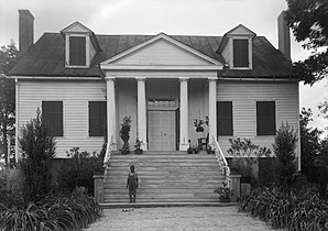
 Boligee Hill (1936) |
|
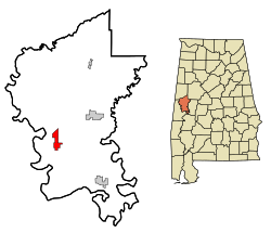
| Location in Alabama | |
| Basic data | |
| Foundation : | 1816 |
| State : | United States |
| State : | Alabama |
| County : | Greene County |
| Coordinates : | 32 ° 46 ′ N , 88 ° 2 ′ W |
| Time zone : | Central ( UTC − 6 / −5 ) |
| Residents : | 328 (as of 2010) |
| Population density : | 32.2 inhabitants per km 2 |
| Area : | 10.2 km 2 (approx. 4 mi 2 ) of which 10.2 km 2 (approx. 4 mi 2 ) is land |
| Height : | 37 m |
| Postal code : | 35443 |
| Area code : | +1 205 |
| FIPS : | 01-08104 |
| GNIS ID : | 0114691 |
Boligee is a city in Greene County in the US state of Alabama . In 2010 the place had 328 inhabitants. The total area of Boligee is 10.3 km².
geography
Boligee is located in western Alabama in the southern United States. The place is about 30 kilometers east of the Mississippi border .
Nearby places include Eutaw (9 km northeast), Epes (9 km southwest), Gainesville (10 km west) and Forkland (15 km southeast). The next larger city with 212,000 inhabitants is about 130 kilometers northeast of Birmingham .
history
The first white settlers was John McKee 1816. For the origin of the name there are several assumptions from the language of the Choctaw : balichi (German: stab , stab ) baluhchi (German: Hickory -Rinde ) abolichi (German: bounce , hit ) , apalichi (German: Holzhauer ), apolichi (German: grain / grain heap ) or aboli ushi (German: small thicket ).
The population grew rapidly, so the first church was built in 1833. At that time, the city center was about 2.4 kilometers away from today's center. In 1838 the city received a post office. In 1853 construction began on a railway line for the Northeast and Southwest Railroad , which was not completed until 1870 due to the Civil War . The new city center was built around the railway line, including a new post office.
In the early 1920s, the St. Louis - San Francisco Railway also built a railway line through the city, creating a railroad crossing in the center.
The city attracted attention in 1996 when three Black Churches were burned down.
One structure in the village is registered on the National Register of Historic Places (NRHP) (as of March 19, 2020), the Boligee Hill property .
traffic
US Highway 11 runs through the south of the city and runs for a length of 2,647 kilometers from Louisiana through the state to New York . Interstate 20 , which runs 2,470 kilometers from Texas to South Carolina , and Interstate 59 run along the northern city limits .
Eutaw Municipal Airport is about 15 kilometers east of the city .
Demographics
According to the 2000 census , Boligee had 369 inhabitants, who were distributed among 150 households and 105 families. The population density was 36 inhabitants / km². 10.57% of the population were white and 88.89% were black. Children under the age of 18 lived in 44% of households. The median income per household was $ 15,000, with 44.9% of the population living below the poverty line .
By the 2010 census , the population had dropped to 328.
Web links
- Statistical data on Boligee (Engl.)
- Boligee in the Encyclopedia of Alabama (Engl.)
Individual evidence
- ^ Website of the US Census Bureau
- ↑ Place Names in Alabama , University of Alabama Press, Tuscaloosa 1989, p. 21 ( on Google Books )
-
↑ Search mask database in the National Register Information System. National Park Service , accessed March 19, 2020.
Weekly List on the National Register Information System. National Park Service , accessed March 19, 2020.

