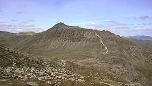
Bowfell
| Bowfell | ||
|---|---|---|
|
Bowfell |
||
| height | 902 m | |
| location | Cumbria , England | |
| Mountains | Cumbrian Mountains | |
| Coordinates | 54 ° 26 '52 " N , 3 ° 9' 59" W | |
|
|
||
Bowfell ( Bow Fell on Ordnance Survey maps ) is one of the 214 Wainwright mountains ( Fell ) in the Lake District National Park in Northern England . Among the fellwalkers (hikers) in the Lake District, this mountain, assigned to the southern Fells , is one of the most popular peaks with numerous variants for the ascent.
topography
The southern Fells include some of England's tallest mountains, arranged in a horseshoe-shaped chain in the area between Great Langdale to the east, Wasdale to the west, Eskdale to the south and Borrowdale to the north: Crinkle Crags , Bowfell, Esk Pike , Great End and As Graduated from Scafell Pike and Sca Fell as the two highest.
While the horseshoe-shaped mountain range includes the upper Eskdale, two other valleys are dominated by the Bowfell: In the east it forms the end of the Great Langdale and divides it with its east ridge ( The Band ) into the valleys Mickleden and Oxendale . In the north it forms the end of the Langstrath valley , a side valley of Borrowdale. In all these valleys it occupies a dominant position at the end and appears as a pyramidal peak on a flat plateau.
The northwest ridge slopes down to the Ore Gap pass , the name of which is derived from the reddish earth present there, which is rich in hematite . Below the pass, to the north, in a basin, is the approximately 15 m deep Angle Tarn , where trout can be found. Its water finds its way north as Langstrath Beck and later flows as the River Derwent over Derwent Water and Bassenthwaite Lake through the towns of Keswick and Cockermouth and flows into the Irish Sea at Workington .
Yeastyrigg Gill rises south of Ore Gap , the water of which later flows into the Irish Sea as Lingcove Beck over the Esk River at Ravenglass .
The southern ridge of Bowfell drops steeply into the saddle Three tarns , and thus forms the transition to Crinkle Crags . This point got its name from a number (mostly two or three, more after heavy rains) small tarns. From here the Busco Sike flows east, forming the main tributary to Oxendale Beck in Great Langdale.
There are two ridges to the east. The largest ( The Band ) divides the upper Great Langdale into the Mickleden and Oxendale valleys and ends at the Stool End farm . Half of the ridge has a small rocky elevation ( White Stones ), which, however, is not recognized as an independent summit by most route descriptions. The second ridge first runs a little north and turns east after a notch at the top of Rossett Gill to form a connection with Rossett Pike . The continuation of this ridge forms with the Langdale Pikes the northern end of the Great Langdale.
Ascents
The Band offers one of the most popular climbs and is preferred by most fellwalkers because of its extensive unobstructed views of Great Langdale and is a popular place to take signature photos of the Lake District mountains.
Other ways to reach the summit are from the Borrowdale valleys past Angle Tarn and from Eskdale over the Ore Gap pass . These routes are much longer and quite time-consuming.
summit
The summit region consists of a ridge with steep rock breaks. The southern side is formed by Bowfell Links , a rock wall with nine vertical gullies . Climbing through these gullies is neither rewarding nor safe as they are filled with very loose gravel.
The east side consists of several large rock breaks and a great slab called an inclined rock slab , which is not unjustifiably named.
The panorama is excellent and almost all of the main mountains of the Lake District are easy to see because of the steep slopes on all sides, as no flat summit plateau obstructs the view.
Remarks
- ^ Pictorial Guide to the Lakeland Fells , Volume 4, The Southern Fells
- ↑ Lake District Place Names , Robert Gambles, Dalesman Books, Clapham 1985
- ^ A b Blair, Don: Exploring Lakeland Tarns : Lakeland Manor Press (2003): ISBN 0-9543904-1-5
- ^ Birkett, Bill: Complete Lakeland Fells : Collins Willow (1994): ISBN 0-00-218406-0
- ^ Richards, Mark: Mid-Western Fells : Collins (2004): ISBN 0-00-711368-4
- ^ Wainwright

