Boxbach
| Boxbach | ||
|
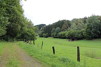
Valley of the Boxbach near the Boxbach pit |
||
| Data | ||
| Water code | DE : 258148 | |
| location |
Westerwald
|
|
| River system | Rhine | |
| Drain over | Perf → Lahn → Rhine → North Sea | |
| source | Border area Hessen / NRW 50 ° 52 ′ 36 ″ N , 8 ° 23 ′ 8 ″ E |
|
| Source height | approx. 467 m above sea level NHN | |
| muzzle | near Breidenbach in the Perf coordinates: 50 ° 53 ′ 53 ″ N , 8 ° 27 ′ 1 ″ E 50 ° 53 ′ 53 ″ N , 8 ° 27 ′ 1 ″ E |
|
| Mouth height | approx. 305 m above sea level NHN | |
| Height difference | approx. 162 m | |
| Bottom slope | approx. 28 ‰ | |
| length | 5.8 km | |
| Catchment area | 13.22 km² | |
| Discharge A Eo : 13.22 km² at the mouth |
MQ Mq |
197 l / s 14.9 l / (s km²) |
| Right tributaries | Gladenbach | |
| Communities | Breidenbach | |
The Boxbach is a 5.8 km long left tributary of the Perf in the northwest of the Gladenbacher Bergland in the area of the municipality of Breidenbach in the central Hessian district of Marburg-Biedenkopf .
The former Boxbach pit and the Boxbach path that crosses the stream are named after the stream .
geography
course
The Boxbach rises on the western border between Breidenbach and Bad Laasphe and not far from the eastern seam of the Breidenbacher Grund , as the north-west of the Gladenbacher Bergland that drains to Perf is called, to the Rothaargebirge , immediately west-south-west of the 561.6 m high Hommerichskopf es.
The stream flows in a north-easterly direction and touches Wiesenbach to the south-east, before finally turning east and flowing into the Perf from the left immediately above the Perf reservoir and north of the core town of Breidenbach.
Tributaries
The most important tributary of the Boxbach is the Gladenbach (2581482), which flows in from the right less than 100 m above its mouth , which previously flowed in parallel to the south-east and touched the district of Kleingladenbach to the south-south-east. With a length of 5.1 km this is only slightly shorter, its catchment area occupies 5.434 km² (Boxbach above: 7.79 km²) about 40% of the Boxbach system.
Tributaries from the source to the mouth
- Mehlbach ( left ), 1.1 km
- Struthgraben [GKZ 25814816] ( left ), 1.1 km
- Lützelbach ( right ), 1.2 km
- Gladenbach ( right ), 5.1 km, 5.43 km²
Web links
Individual evidence
- ↑ a b c d Water map service of the Hessian Ministry for the Environment, Climate Protection, Agriculture and Consumer Protection ( information )
- ↑ Designation according to the property map
