
Brain-sur-Longuenée
| Brain-sur-Longuenée | ||
|---|---|---|
|
||
| local community | Erdre-en-Anjou | |
| region | Pays de la Loire | |
| Department | Maine-et-Loire | |
| Arrondissement | Segré | |
| Coordinates | 47 ° 35 ′ N , 0 ° 46 ′ W | |
| Post Code | 49220 | |
| Former INSEE code | 49043 | |
| Incorporation | December 28, 2015 | |
| status | Commune déléguée | |
| Website | http://www.brainsurlonguenee.com/ | |
 Town hall (Mairie) of Brain-sur-Longuenée |
||

Brain-sur-Longuenée is a town and commune Déléguée in the French community Erdre-en-Anjou with 943 inhabitants (943) in the department of Maine-et-Loire in the region of Pays de la Loire . The inhabitants are called the Brainois .
With effect from December 28, 2015, the municipalities of Brain-sur-Longuenée , Gené , La Pouëze and Vern-d'Anjou were merged into a nouvelle commune called Erdre-en-Anjou. The municipality of Brain-sur-Longuenée was part of the Arrondissement of Segré and the canton of Tiercé (until 2015: Canton Le Lion-d'Angers ).
location
Brain-sur-Longuenée is about 26 kilometers northwest of Angers .
Population development
| year | 1962 | 1968 | 1975 | 1982 | 1990 | 1999 | 2006 | 2013 |
| Residents | 602 | 568 | 513 | 574 | 669 | 768 | 927 | 963 |
| Source: Cassini and INSEE | ||||||||
Attractions
- Saint Didier Church
- Chapel of Sainte-Anne
- Hermitage Chapel of Le Puits Hervé
- Montergon Castle, built around 1673
- La Maison-Blanche Castle
- La Himbaudière mansion
- Town hall, former rectory, from the 15th century
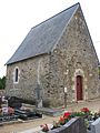
Chapel of Sainte-Anne

Montergon Castle


literature
- Le Patrimoine des Communes de Maine-et-Loire . Flohic Editions, Volume 2, Paris 2001, ISBN 2-84234-117-1 , pp. 699-701.
Web links
Commons : Brain-sur-Longuenée - collection of images, videos and audio files