Broderkonsberg
| Broderkonsberg | ||
|---|---|---|
|
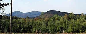
View from Asberg to Broderkonsberg (front) |
||
| height | 378.4 m above sea level NHN | |
| location | North Rhine-Westphalia , Germany | |
| Mountains | Westerwald | |
| Coordinates | 50 ° 38 '30 " N , 7 ° 17' 2" E | |
|
|
||
The Broderkonsberg is 378.4 m above sea level. NHN high mountain in the north of the Rheinwesterwald volcanic ridge ( Niederwesterwald ) in the area of the city of Bad Honnef .
geography
The Broderkonsberg is just under two kilometers west of Aegidienberg and three and a half kilometers east of the city center of Bad Honnef in the Siebengebirge nature park and the nature reserve of the same name . It is the eastern and highest elevation of the so-called Dreiergipfels , which is formed by Broderkonsberg, Mittelberg and Himmerich and towers over the surrounding plateau of the Rheinwesterwald volcanic ridge by about 60 m. The mountain peak has a strikingly steep slope angle between 15 ° and 20 °, is forested and not accessible via regular hiking trails. The Stellweg runs along the north-eastern ridge , a straight aisle path that leads in the upper area of the Siebengebirge nature park from the northern edge of the Asberg (southern city limits of Bad Honnef) to Ittenbach . The Stenzbach , which can be seen as the upper reaches of the Ohbach , rises on the north side of the mountain .
geology
The Broderkonsberg is considered to have a complex petrographic structure. It consists of trachyte , Quarztrachyt tuff and silica -untersättigtem hawaiite .
history
The name of the mountain was originally "Bruderkunzberg", after a hermit of the same name. In the topographical survey of the Rhineland carried out at the beginning of the 19th century , it was referred to as the Brudiconsberg . Local field names are (Am) Proticonsberg and Vor and Hinter dem Protokonsberg .
Web links
- Broderkonsberg at tourenwelt.info
Individual evidence
- ↑ a b Information according to the digital terrain model and digital topographic map 1: 25,000 (available from the TIM-online map service )
- ↑ Landschaftsverband Rheinland , Landscape Planning Department (ed.); Harald Zepp : Siebengebirge Nature Park. Contents of the present natural and landscape basics (= contributions to regional development , 39). Rheinland-Verlag, Cologne 1982, ISBN 3-792-70706-3 , p. 21.
- ^ Geological State Office North Rhine-Westphalia (ed.); Gangolf Knapp, Klaus Vieten: Geological map of North Rhine-Westphalia 1: 25,000. Explanations for sheet 5309 Königswinter . 3rd, revised edition, Krefeld 1995, pp. 30-32.
- ↑ J. Josef Schmitz et al .: Flora Bonnensis . Verlag König, 1841, p. X ( Google Books [accessed October 20, 2016]).
- ^ Contributions to name research , Volume 10, Verlag C. Winter, 1959, p. 190.
- ↑ Helmut Arntz (with the assistance of Adolf Nekum ): Urkataster und Gewannen: using the example of the community of Honnef 1824/1826 . (= Local history and history association “Herrschaft Löwenburg” eV : studies on the local history of the city of Bad Honnef am Rhein. Issue 13). Bad Honnef 2000.
- ^ Society for the History of Wine e. V .: Writings on wine history , ISSN 0302-0967 , No. 133, Wiesbaden 2000, p. 69.

