
Bruna (river)
| Bruna | ||
 The Bruna River at Ponti di Badia (Castiglione della Pescaia) |
||
| Data | ||
| location | Italy , Tuscany ( Province of Grosseto ) | |
| River system | Bruna | |
| River basin district | Appennino Settentrionale | |
| source |
Massa Marittima ( Province of Grosseto ) 43 ° 2 ′ 8 " N , 10 ° 53 ′ 43" E |
|
| muzzle |
Castiglione della Pescaia in the Tyrrhenian Sea Coordinates: 42 ° 45 '44 " N , 10 ° 52' 59" E 42 ° 45 '44 " N , 10 ° 52' 59" E
|
|
| length | 41 km | |
| Catchment area | 350 km² | |
| Left tributaries | Asina, possa | |
| Right tributaries | Sovata | |
| Flowing lakes | Lake Accesa | |
| Reservoirs flowed through | Bruna dam | |
| Medium-sized cities | Grosseto | |
| Communities | Roccastrada , Massa Marittima , Gavorrano , Castiglione della Pescaia | |
| Ports | Castiglione della Pescaia | |
The Bruna is a 41 km long river in Italy that crosses the province of Grosseto ( Tuscany ) from north to south and flows into the Tyrrhenian Sea in Castiglione della Pescaia .
course
The river rises south of Massa Marittima in the hills of the Colline Metallifere and then flows through the lake Lago dell'Accesa . He leaves the municipality of Massa Marittima after 2 km and flows through the municipality of Gavorrano for 4 km, where he meets the ruins of the Bruna dam . Near the hamlet of Castellaccia , the tributary Asina flows in from Roccastrada from the left , then it becomes the border river between the municipalities of Roccastrada and Gavorrano for 3 km, whereby it flows under the Via Aurelia at Giuncarico (Gavorrano) . West of Montepescali (district of Grosseto ) the river becomes the border river between Grosseto (east) and Castiglione della Pescaia (west). Here, near Macchiascandona (also called Macchia Scandona , district of Castiglione della Pescaia), the tributary Sovata flows in from the right . At Badiola it passes the district of Ponti di Badia (Castiglione della Pescaia) with its bridge and a few meters later in the nature reserve Riserva naturale Diaccia Botrona passes completely to the area of Castiglione della Pescaia. Shortly before the port of Castiglione della Pescaia, he passes the 26 meter long bridge Ponte Gaetano Giorgini , begun in October 1827 and completed in May 1828 , which was named after the architect (1795–1874). After the port of Castiglione della Pescaia, the river flows into the Tyrrhenian Sea .
history
The river, formerly also known as Salebro or Salabrone , was first mentioned in 790 as Fluvio Brona by the Archbishop of Lucca , John I (781-800), who defined the river as the border with Gavorrano. In 1038 the river appears on maps as Fluvio Brama , 1051 as Brone , 1305 as Flumen Brunarum . In the statutes of Montepescali he is listed in 1427 as Fiume de le Brone . The Bruna dam was built in 1470, but collapsed in 1492. The first measures for amelioration were probably already carried out by the Etruscans and the Romans , the modern works were carried out between 1828 and 1848 by the Grand Duke of Tuscany, Leopold II.
photos

The Bruna at Ponti di Badia / Badiola

The Ponte Gaetano Giorgini bridge in Castiglione della Pescaia
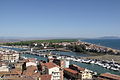
The Ponte Gaetano Giorgini bridge and the port in Castiglione della Pescaia

The last meters of the Bruna before the mouth in Castiglione della Pescaia


literature
- Emanuele Repetti: Dizionario Geografico Fisico Storico della Toscana Online edition of the University of Siena on Castiglione della Pescaia and the Bruna river
Web links
- Fiumi Italiani website on the Bruna River
- Official website of the Comune di Grosseto (Atlante Storico Topografico) on the Bruna River (Italian)
Individual evidence
- ↑ Official website of the Sistema Informativo Ambientale della Regione Toscana (SIRA) on the Bruna River, accessed on February 3, 2012 (Italian)
- ↑ a b Official website of the University of Florence, accessed on February 3, 2012 (Italian) (PDF file; 1.06 MB)
- ↑ website DBI (Dizinario Biografico degli Italiani) to the biography Giorginis retrieved (Italian) 3 February 2012
- ↑ cf. Repetti
- ^ Website of the Atlante Storico Topografico of the Comune di Grosseto on the history of the Bruna River, accessed on February 3, 2012 (Italian)
- ^ Website of the Atlante Storico Topografico of the Comune di Grosseto for the improvement of the river Bruna, accessed on February 3, 2012 (Italian)