Bukovské vrchy
| Bukovské vrchy | ||
|---|---|---|
|
The Bukovské vrchy within the Slovenské stredohorie (Slovak Central Mountains) |
||
| Highest peak | Kremenec ( 1208 m nm ) | |
| location | Slovakia | |
| part of | East Beskids | |
| Classification according to | Geomorphological classification of Slovakia | |
|
|
||
| Coordinates | 49 ° 5 ' N , 22 ° 20' E | |
| particularities | Slovak spatial unit, summit at 1221 m (PL / UA) | |
The Bukovské vrchy ('Bukovec Mountains') are a mountainous spatial unit in the Slovak part of the Forest Carpathians . They are named after the Bukovec massif .
Location, boundary and subdivision
The mountains are located in northeastern Slovakia on the borders with Poland and Ukraine . Geomorphologically it forms a unit with the Bieszczady on the Polish side. However, the term Bukovské vrchy is only used for the Slovak part of the mountains.
In general, the Bukovské vrchy are part of the Polonines and thus the - geomorphologically not precisely defined - Forest Carpathians .
You will be limited:
- in the north of the Polish state border and thus the Bieszczady ,
- to the east of the Ukrainian state border,
- in the south of the Beskydské predhorie ,
- to the west of the Laborecká vrchovina (part of the Low Beskids ).
The mountain range is further subdivided geomorphologically into:
- Bukovce
- Ruská kotlina
- Runinská kotlina
- Sedlická kotlina
- Uličská kotlina
- Nastaz
character
The Bukovské vrchy are made of flysch ( sandstone and claystone ). From the main ridge - which lies on the border with Poland - side ridges stretch south. Characteristic are mountain meadows in the ridge area, the so-called polonines, after which the entire mountain complex got its name.
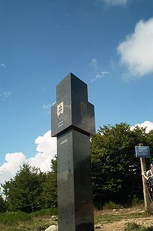
The highest point of the mountains on Slovak territory is the southwest flank of the Kremenec mountain at an altitude of 1208 m nm. The summit of this mountain ( 1221 m nm ) is about 200 m in a north-easterly direction on the border between Poland and Ukraine.
The area is drained to the south by the rivers Ulička and Ublianka (tributaries of the Usch ) and Cirocha (tributary of the Laborec ).
The region is predominantly forested; deciduous forests dominate here (especially red beech , sycamore maple ). Among the conifers, the silver fir is worth mentioning.
Significant surveys
- Kremenec, 1221 m nm / 1208 m nm
- Kamienna, 1201 m nm
- Ďurkovec, 1198 m nm
- Rabia scale, 1167 m nm
- Pľaša, 1162 m nm
- Stinska, 1092 m nm
- Veľký Bukovec, 1012 m nm
natural reserve
In 1997, the Poloniny National Park ( Národný park Poloniny ) was established, which includes large parts of the Bukovské vrchy. It has an area of 298 km² and a surrounding protection zone of 110 km². The Eastern Carpathian Protected Landscape Area ( Chránená krajinná oblasť Východné Karpaty ) connects to this , so that practically the entire mountain range is under protection.
In 2007, a total of ten areas in the Eastern Carpathians - four of which are in Slovakia and six in Ukraine - were declared a World Heritage Site by UNESCO . Three of these areas are in the Bukovské vrchy:
population
The Bukovské vrchy are among the most recently and sparsely populated areas of Slovakia. Most of the residents belong to the Russian minority .
Attractions
The region is attractive in terms of landscape and has not yet been well-developed for tourists and is suitable for hiking and cycling tourism. Apart from the ridge region and the primeval beech forests, several wooden churches are also worth seeing ( Topoľa , Uličské Krivé , Ruský Potok , Kalná Roztoka , Jalová ).


