Castle Little France
| Little France | ||
|---|---|---|
|
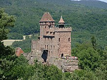
Remains of the battery tower of the castle Little France |
||
| Alternative name (s): | Thurm France | |
| Creation time : | 1484 | |
| Castle type : | Höhenburg, hillside location | |
| Conservation status: | ruin | |
| Standing position : | Knight | |
| Construction: | Sandstone blocks, e.g. T. with pincer holes | |
| Place: | Erlenbach near Dahn | |
| Geographical location | 49 ° 6 '18 " N , 7 ° 51' 46" E | |
| Height: | 322 m above sea level NHN | |
|
|
||
Little France , also called Thurm France , is the ruin of the early modern foreworks of a medieval hillside castle in the southern Palatinate Forest , the German part of the Wasgau , in the district of Südwestpfalz ( Rhineland-Palatinate ). As a Vorwerk, it used to belong to the nearby Berwartstein Castle .
Geographical location
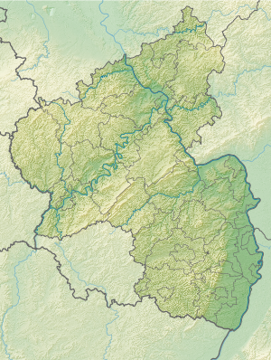
The castle is located in the Dahner Felsenland above the municipality of Erlenbach at 322 m above sea level. NHN on the northern slope of the 402 m high Nestelberg .
About 370 m to the north, across a saddle-shaped side valley, is the main castle Berwartstein at an altitude of 280 m . In the west, at the junction from the main valley, which is formed by the floodplain of the Erlenbach , the side valley, popularly known as the “Leichenfeld”, is widened like a trough.
Because the last stretch of the route leads over forest paths that are not approved for public motor vehicle traffic, Little France, unlike the main castle, cannot be reached by car. You can get there from the small town of Dahn on federal road 427 (towards Bad Bergzabern ), state road 490 (towards Niederschlettenbach ) and district road 50 (towards Berwartstein). But instead of turning right up to Berwartstein, you have to continue on the K 50 for about 150 m - along the eastern edge of the "Leichenfeld". From there you can take about 500 m of forest paths up to the Vorwerk.
Castle complex
The stump of a large battery tower with a diameter of 14 m and originally the same height is quite well preserved . Its wall thickness is 3.20 m; some of the stone blocks have pincer holes. The first floor wall is pierced by three loopholes, the first floor by four. Hook rifles and small guns could be shot through the openings . The roof platform was wide enough to set up field snakes , the longer pipes of which increased accuracy.
To the north of the tower are the remains of a curtain wall that used to surround it; immediately to the northeast is a filled well .
Little France is said to have been connected to the main castle Berwartstein by a hidden passage . This speculation arose because the remains of a trench covered with stone slabs and covered with earth and plants were found near the Vorwerk; almost all of it collapsed.
history
How Little France got its unusual name is still unclear; however, it is from the Berwartstein in the direction of France , whose current border is only 7 km away. In 1511 it was mentioned in a document as Thurm France .
It was built in 1484 by the knight Hans von Trotha , later often referred to as Hans Trapp in the vernacular , as an outpost of the Berwartstein. As a Vorwerk it served to take the "corpse field" from the north (Berwartstein) and south (Little France) under fire from two sides . The mountain saddle with the significant name was the only place where the siege cannons of the time could be set up close enough to the Berwartstein. In fact, until 1591, when it burned out after a lightning strike and became uninhabitable for three centuries, it was never conquered again despite various attempts; this may also be due to the existence of the auxiliary castle.
After the main castle had been abandoned for decades, the outwork was significantly damaged in the 17th century, either in the Thirty Years War or in the War of the Palatinate Succession . The restoration of the remains began in 2005.
literature
- Eckhard Braun: Palatinate castles and firearms . Gabriele Meyer Verlag, Hauenstein 1997, ISBN 3-927891-07-X .
- Little France . In: Jürgen Keddigkeit , Ulrich Burkhart, Rolf Übel (eds.): Palatinate Castle Lexicon . tape 3 , I-N. District Association of the Palatinate, Institute for Palatinate History and Folklore, Kaiserslautern 2005, ISBN 978-3-927754-54-6 .
- Günter Stein : Little France . In: Castles and palaces in the Palatinate . Droemer Knaur, Munich 1988, ISBN 978-3-426-04405-6 .
Web links
Individual evidence
- ^ LANIS: Topographic Map. Retrieved August 9, 2020 .
- ↑ a b c d Rolf Übel: Little France (VG Dahner Felsenland). heimat-pfalz.de, accessed on October 7, 2014 .
- ↑ a b Eckhard Braun: Palatinate castles and firearms . 1997, p. 406 .


