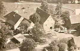
Burggrub (Krummennaab)
|
Burggrub
Krummennaab municipality
Coordinates: 49 ° 49 ′ 28 " N , 12 ° 5 ′ 43" E
|
|
|---|---|
| Height : | 457 m above sea level NHN |
| Residents : | 99 (1987) |
| Incorporation : | 1939 |
| Postal code : | 92703 |
| Area code : | 09682 |
|
The Burggrub district of Krummennaab
|
|
Burggrub is one of 17 officially named districts of the Upper Palatinate municipality of Krummennaab in the Tirschenreuth district .
geography
The village is located about 800 meters southwest of the center of Krummennaab at an altitude of 457 m above sea level. NHN . Naturally, Burggrub is located on the high bank of the Fichtelnaab on the right-hand side , the right or western source river of the Waldnaab .
history
The first written mention of the place took place in 1373 under the name Gruob . The Franconian / Upper Palatinate noble family von Trautenberg had a castle seat built here, which was built on the basis of a fief given by the Hohenzollern rulers of the burgraviate of Nuremberg . After the Trautenberg family, the estate came into the possession of the von Mylin family , who sold it to a certain Ulrich from the von Redwitz family in 1373 . The following noble families in ownership were von Brandt in 1567 , von Stiebar in 1597 and in the same year von der Grün , from 1629 to 1861 then von Saurzapf .
Unlike the north-eastern areas of this region, Burggrub did not belong to the Electorate of Baiern until the creation of Pfalz-Baiern in 1777 , but, like Krummennaab, to the Electorate of Pfalz-Sulzbach .
As a result of the administrative reforms carried out in the Kingdom of Bavaria at the beginning of the 19th century , the place became an independent rural community. However, this was incorporated into the municipality of Krummennaab more than three decades before the municipal territorial reform in Bavaria carried out in the 1970s , to which at that time the village of Trautenberg , the hamlets of Lehen and Sassenhof and the wasteland of Reisermühle still belonged. In 1987 Burggrub had 99 inhabitants.
traffic
The connection to the public road network is provided by State Road 2121 , which, coming from the north-east of Krummennaab, runs through the northwestern local area and shortly thereafter joins State Road 2181 . Otherwise, there is only a communal road from Burggrub to the neighboring village of Reisermühle, about half a kilometer to the northwest.
Attractions
In the village there is the former Burggrub Castle, a listed building, see the list of architectural monuments in Burggrub .
literature
- Gertrud Diepolder : Bavarian History Atlas . Ed .: Max Spindler . Bayerischer Schulbuch Verlag, Munich 1969, ISBN 3-7627-0723-5 .
Web links
- Burggrub in the BayernAtlas , accessed on December 3, 2018
- Burggrub on historical map , accessed December 3, 2018
Individual evidence
- ↑ a b Population of Burggrub , accessed on December 3, 2018
- ^ Burggrub in the local database of the Bavarian State Library Online . Bayerische Staatsbibliothek, accessed on December 3, 2018.
- ↑ Geographical location of Burggrub in the BayernAtlas , accessed on December 3, 2018
- ↑ a b History of Burggrub , accessed on December 3, 2018
- ↑ Gertrud Diepolder : Bavarian History Atlas . Ed .: Max Spindler . Bayerischer Schulbuch Verlag, Munich 1969, ISBN 3-7627-0723-5 . , Page 31
- ↑ Composition of the municipality of Krummennaab , accessed on December 3, 2018


