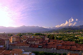
Candelo
| Candelo | ||
|---|---|---|

|
|
|
| Country | Italy | |
| region | Piedmont | |
| province | Biella (BI) | |
| Coordinates | 45 ° 33 ' N , 8 ° 7' E | |
| height | 321 m slm | |
| surface | 15 km² | |
| Residents | 7,420 (Dec. 31, 2019) | |
| Population density | 495 inhabitants / km² | |
| Post Code | 13878 | |
| prefix | 015 | |
| ISTAT number | 096012 | |
| Website | Candelo | |
 Ricetto di Candela (front) |
||
Candelo is an Italian commune with 7420 inhabitants (as of December 31, 2019) in the province of Biella (BI) in the Piedmont region and is the holder of the Bandiera Arancione of the TCI .
geography
The municipality covers an area of 15 km². It borders the provincial capital Biella to the southeast.
The neighboring municipalities are Benna , Biella , Cossato , Gaglianico , Valdengo , Verrone and Vigliano Biellese .
Attractions
Candelo is known for the Ricetto di Candelo , a fortified and very densely built-up area in the Middle Ages, which served as a refuge in troubled times . This district belongs to the association I borghi più belli d'Italia (The Most Beautiful Places in Italy).
Culinary specialties
Viticulture is practiced in the area around Candelo . The vine material is used in the DOC - Wine Coste della Sesia .
photos
Town twinning
Candelo is twinned with La Roche-sur-Foron in the French department of Haute-Savoie .
Web links
Individual evidence
- ↑ Statistiche demografiche ISTAT. Monthly population statistics of the Istituto Nazionale di Statistica , as of December 31 of 2019.
- ↑ Bandiera Arancione. In: Bandierearancioni.it. Retrieved April 18, 2018 (Italian).
- ^ Ricetto di Candelo. In: Borghipiubelliditalia.it. Retrieved April 18, 2018 (Italian).
- ↑ Da Candelo all'Europa. In: comune.candelo.bi.it. Retrieved April 18, 2018 (Italian).


