Cherlen (river)
|
Cherlen Kerulen, Herlen He |
||
|
Location of the Cherlen |
||
| Data | ||
| location | Inner Mongolia ( PRC ), Mongolia | |
| River system | Amur | |
| Drain over | Hulun Nur → (temporarily Argun → Amur → Tatar Sound) | |
| Headwaters |
Chentii Mountains 48 ° 47 ′ 53 " N , 109 ° 11 ′ 44" E |
|
| muzzle |
Hulun Coordinates only : 48 ° 45 ′ 55 " N , 117 ° 2 ′ 53" E 48 ° 45 ′ 55 " N , 117 ° 2 ′ 53" E |
|
| Mouth height |
539 m
|
|
| length | 1264 km | |
| Catchment area | 116,400 km² | |
| Discharge at the Choibalsan A Eo gauge : 66,400 km² |
MQ 1947/1957 Mq 1947/1957 |
15.3 m³ / s 0.2 l / (s km²) |
| Medium-sized cities | Tschoibalsan | |
| Small towns | Öndörchaan , Bail-Sagan | |
|
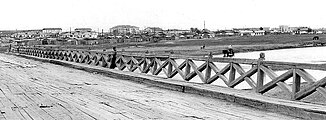
Bridge over the Cherlen near Chojbalsan (1972) |
||
| Mongolian name | |
|---|---|
| Mongolian script : | ᠺᠡᠷᠦᠯᠡᠨ ᠭᠣᠣᠯ |
| Transliteration: | kerulen ɣool |
| Official transcription of the PRCh: | Herlen gol |
| Cyrillic script : | Хэрлэн гол |
| ISO transliteration : | Xèrlèn gol |
| Transcription: | Cherlen gol |
| Other spellings: | Kerulen |
| Chinese name | |
| Simplified : | 克鲁伦河 |
| Pinyin : | Kèlǔlún Hé |
The Kherlen (old name: Kerulen , Mongolian Хэрлэн гол ) is a 1264 kilometer long inland river in Mongolia and northern China ( East Asia ). Within Mongolia, the Cherlen has a length of 1090 km, making it the second longest river in Mongolia after the Orkhon .
After crossing the Mongolian Gulti steppe and the peripheral areas of some large salt pans, it ends in Lake Hulun Nur , which, however, has an outflow to the river system of the Argun and Amur in rainy years .
River course
The river has its source about 180 kilometers northeast of Ulaanbaatar on the southern slope of the Mongolian Chentii Mountains (Kentei). After about 200 km it changes its course to the east, flows through extensive steppe areas of eastern Mongolia and here passes the cities of Öndörchaan , Bail-Sagan and Tschoibalsan (Kerulen).
After a clear turn to the north and a sharp turn back to the south, it crosses the border to northeast China, into Inner Mongolia , at around river kilometer 1090 . There it flows another 164 kilometers to the east and flows into the steppe lake Hulun Nur near the Russian border with eastern Siberia .
The Onon rises about 45 kilometers further north from the headwaters of the Cherlen . This initially runs parallel to the Cherlen, but then flows over eastern Siberia into the Amur river basin .
Cherlen-Argun-Amur
In rainy years it happens that the Hulun Nur, which normally has no drainage, overflows on its north bank to flow into the Argun after about 30 kilometers. This gives the Cherlen a connection to the Argun , which from there forms the Sino-Russian border for a length of 944 kilometers and then the Amur , so that the Cherlen-Argun-Amur river runs 5052 kilometers long .
Individual evidence
- ↑ a b c Article Cherlen in the Great Soviet Encyclopedia (BSE) , 3rd edition 1969–1978 (Russian)
- ↑ UNESCO: Level data from Choibalsan ( Memento of the original from March 3, 2016 in the Internet Archive ) Info: The archive link was inserted automatically and has not yet been checked. Please check the original and archive link according to the instructions and then remove this notice.
- ^ Werner Elstner: Mongolia. Berlin 1993, p. 16.

