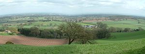
Cheshire Plain
The Cheshire Plain is a relatively low relief lowland , which is almost entirely in the county of Cheshire in north-west England . It stretches from the Mersey Valley in the north to the Shropshire Hills in the south and is bounded to the west by the hill country of North Wales and to the northeast by the foothills of the Pennines . It is drained by the River Weaver . The Peninsula Wirral joins the northwest, while the Cheshire Plain to the north in the area of Manchester in the coastal plain of Lancashire ( West Lancashire Coastal Plain passes).
geology
The Cheshire Plain is made up of two areas separated by the Mid Cheshire Ridge , a north-south chain of hills of sandstone , each of which has its own character and of which the east is larger.
It is the superficial expression of the Cheshire Basin, a deep Paleozoic - Mesozoic sedimentary basin that continues north to below Lancashire and south to below Shropshire . About 220 million years ago, deposits of salt minerals formed after flooding. Today's landscape has been through the front of around 20,000 to 15,000 years consumable ice of the last ice age formed the a thick layer of glacial till and widespread deposits outwash left of sand and gravel, either the retreating glacier or at that time spreading alluvial attributed . The shallow lakes and swamps created at that time are habitats with a great diversity of species. Natural leaching of salt deposits resulted in subsidence and the formation of further lakes and swamps, the so-called flashes .
Settlements
Major cities are Congleton , Crewe , Knutsford , Macclesfield , Nantwich , Northwich , Wilmslow and Winsford .
Economy and Transport
Due to the prevailing weather conditions, the Cheshire Plain is mainly used for dairy farming because of the prevailing weather conditions and is therefore characterized by fields and pastures enclosed by hedges .
Rock salt was mined until the 19th century and then mainly by leaching, first around Northwich and now near Winsford. In marl pits, calcareous material was extracted for fertilization. Quartz sand is mainly mined in the eastern part of the Cheshire Plain between Congleton, Sandbach , Holmes Chapel and Chelford .
The flat topography allowed railway lines such as the West Coast Main Line , the Mid-Cheshire Line and the routes from Crewe to Chester , Manchester and Shrewsbury to be built with slight inclines and few curves. Canals such as the Macclesfield Canal , the Shropshire Union Canal (Middlewich Branch) and the Trent and Mersey Canal , built in the 18th and 19th centuries for the carriage of goods, are now used by recreational boating. Important road connections are the M6 motorway , which runs roughly in a north-south direction, as well as the A Roads A34, A50, A51, A54, A500, A530, A537, A 556 and A559.
meteorology
In meteorology, the Cheshire Plain lowlands are referred to as the Cheshire Gap because it provides weather systems with a path between the hills and mountains of the Clwydian Range in Wales on the one hand and the Peak District and the southern Pennines on the other, which is significantly farther than elsewhere inland from the coast of the Irish Sea . The location on the leeward side of the north Welsh hills and mountains results in a relatively humid climate.
See also
Further information
- About the area - Cheshire and Wirral and its habitats for birds . Retrieved November 12, 2015. Geography and Geology Overview
- Cheshire East Council: Landscape Character Assessment - 4.5 Cheshire Plain . Retrieved November 12, 2015. Landscape characteristics
Individual evidence
- ↑ Natural England - Cheshire . Natural England. Archived from the original on June 5, 2014. Retrieved November 11, 2015.
- ^ EM Yates: A Contribution to the Glacial Geomorphology of the Cheshire Plain . In: Royal Geographical Society (with the Institute of British Geographers) (Ed.): Transactions of the Institute of British Geographers . 42, 1967, pp. 107-125. doi : 10.2307 / 621375 .
- ^ DS Peake: Glacial changes in the River Alyn system and their significance in the glaciology of the North Welsh border . In: QJ Geol. Soc. London . 117, 1961, pp. 335-366.
- ^ EA Francis: Quaternary Research Association Field Handbook. Annual Field Meeting. . University of Keele, 1978, pp. 39-59.
- ↑ a b T. Bowerman et al .: Meres and Mosses: important habitats along Cheshire's sandstone ridge . Archived from the original on March 5, 2016. Info: The archive link was inserted automatically and has not yet been checked. Please check the original and archive link according to the instructions and then remove this notice. Retrieved November 12, 2015.
- ^ A b G. E. Norton et al .: Mineral Resource Information in Support of National, Regional and Local Planning. Cheshire (comprising Cheshire, Boroughs of Halton and Warrington) . British Geological Survey, 2006.
- ↑ John P. Birchall: Deep History of Cheshire . Retrieved November 12, 2015.
Coordinates: 53 ° 12 ′ 0 ″ N , 2 ° 28 ′ 0 ″ W.
