
Chhusang
| Chhusang छुसाङ |
|||
|---|---|---|---|
|
|||
| Coordinates | 28 ° 55 ' N , 83 ° 49' E | ||
| Basic data | |||
| Country | Nepal | ||
| Gandaki | |||
| Zone | Dhaulagiri | ||
| ISO 3166-2 | NP-P4 | ||
| District | mustang | ||
| Residents | 512 (2011) | ||
 |
|||

Chhusang ( Nepali छुसाङ ) is a Village Development Committee (VDC) in the Mustang District ( Nepal ) in the upper river valley of the Kali Gandaki .
The main town Chhusang is 17 km north of Jomsom on the eastern bank of the Kali Gandaki at the mouth of the Narshing Khola . Chhusang is on the trekking route from Jomsom to Lo Manthang .
Residents
At the 2011 census, Chhusang had 512 inhabitants (247 of them male) in 168 households.
Villages and Hamlets
Chhusang consists of several villages and hamlets :
- Bhena ( 3805 m ⊙ )
- Chele ( 3060 m ⊙ )
- Chhomnang ( 2970 m )
- Chhusang ( 2950 m ⊙ )
- Ghok ( 4100 m ⊙ )
- Ghyakar ( 3370 m ⊙ )
- Kyuten ( 3548 m )
- Samar ( 3620 m ⊙ )
- Tetang ( 3060 m ⊙ )
- Thangbe ( 3020 m ⊙ )
![]() Map with all coordinates of the section Villages and Hamlets : OSM
Map with all coordinates of the section Villages and Hamlets : OSM
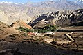
- Chhusang
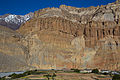
Cliffs at Chhusang

Chhusang

Kali Gandaki Bridge at Chele

Chele
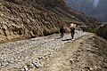
Way Chele - Samar
Samar

Ghyakar

Thangbe


Web links
Commons : Chhusang - collection of images, videos and audio files
Individual evidence
- ↑ National Population and Housing Census 2011 (PDF) Central Bureau of Statistics. Archived from the original on July 31, 2013.
- ^ District: Mustang. List of Settlements (PDF) In: Index of Geographical names of Nepal . National Geographic Information Infrastructure Program. www.ngiip.gov.np. Archived from the original on February 6, 2016. Info: The archive link was inserted automatically and has not yet been checked. Please check the original and archive link according to the instructions and then remove this notice. Retrieved April 15, 2014.