
Kagbeni (Mustang)
| Kagbeni कागबेनी |
|||
|---|---|---|---|
|
|||
| Coordinates | 28 ° 50 ′ N , 83 ° 47 ′ E | ||
| Basic data | |||
| Country | Nepal | ||
| Gandaki | |||
| Zone | Dhaulagiri | ||
| ISO 3166-2 | NP-P4 | ||
| District | mustang | ||
| height | 2830 m | ||
| Residents | 937 (2011) | ||
 Kagbeni from the north
|
|||

Kagbeni ( Nepali कागबेनी ) is a village and a Village Development Committee in the Mustang district in the upper river valley of the Kali Gandaki .
The place Kagbeni is on the left bank of the Kali Gandaki at an altitude of 2830 m at the confluence of the tributary Jhong Khola . The place is on the road from Jomsom, just under 10 km south, to Muktinath, 10 km east .
Residents
At the 2011 census, Kagbeni had 937 inhabitants (461 men) in 274 households.
Villages and Hamlets
Kagbeni consists of several villages and hamlets :
- Dhagarjung ( 3220 m ⊙ )
- Ekle Bhatti ( 2780 m ⊙ )
- Ili ( 2830 m )
- Kagbeni ( 2830 m ⊙ )
- Lembibuk ( 2950 m )
- Panda ( 2780 m )
- Pangling ( 2909 m ⊙ )
- Phallyak ( 3140 m ⊙ )
- Sangta ( 3770 m ⊙ )
- Tirigaun ( 2860 m ⊙ )
![]() Map with all coordinates of the section Villages and Hamlets : OSM
Map with all coordinates of the section Villages and Hamlets : OSM
- Kagbeni

Kali Gandaki near Kagbeni

Fields south of Kagbeni
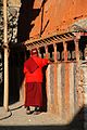
Gompa with monk at prayer wheels

New monastery building

Fountain in the center

Meme mom

Pack horses and their master

Way to the north with a watchtower


Web links
Individual evidence
- ↑ National Population and Housing Census 2011 (PDF) Central Bureau of Statistics. Archived from the original on July 31, 2013.
- ^ District: Mustang. List of Settlements (PDF) In: Index of Geographical names of Nepal . National Geographic Information Infrastructure Program. www.ngiip.gov.np. Archived from the original on February 6, 2016. Info: The archive link was inserted automatically and has not yet been checked. Please check the original and archive link according to the instructions and then remove this notice. Retrieved April 15, 2014.