Chihaya Akasaka (Osaka)
| Chihaya-Akasaka-mura 千 早 赤阪 村 |
||
|---|---|---|
| Geographical location in Japan | ||
|
|
||
| Region : | Kinki | |
| Prefecture : | Osaka | |
| Coordinates : | 34 ° 28 ' N , 135 ° 27' E | |
| Basic data | ||
| Surface: | 37.38 km² | |
| Residents : | 4921 (October 1, 2019) |
|
| Population density : | 132 inhabitants per km² | |
| Community key : | 27383-0 | |
| Symbols | ||
| Flag / coat of arms: | ||
| town hall | ||
| Address : |
Chihaya-Akasaka Village Hall 180 Ōaza Suibun Chihaya-Akasaka -mura, Minamikawachi-gun Ōsaka 585-8501 |
|
| Website URL: |
www.vill.chihayaakasaka. osaka.jp |
|
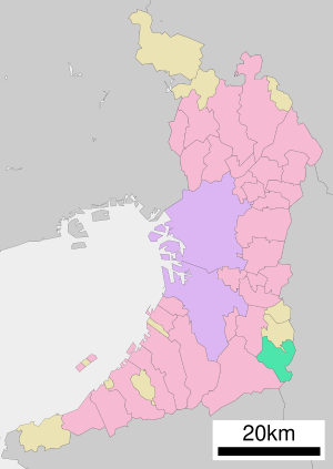
| Location Chihaya-Akasakas in Osaka Prefecture | ||
Chihaya-Akasaka ( Japanese 千 早 赤阪 村 , -mura ) is a village in Minamikawachi-gun in Osaka Prefecture . Due to the amalgamation of many areas, Chihaya-Akasaka is the only village parish in the prefecture.
geography
Chihaya-Akasaka is located southeast of Osaka .
traffic
- Street:
- National Road 309
Neighboring cities and communities
- Osaka prefecture
- Nara prefecture
Web links
Commons : Chihayaakasaka, Osaka - Collection of pictures, videos and audio files


