Takatsuki
| Takatsuki-shi 高 槻 市 |
||
|---|---|---|
| Geographical location in Japan | ||
|
|
||
| Region : | Kinki | |
| Prefecture : | Osaka | |
| Coordinates : | 34 ° 51 ' N , 135 ° 37' E | |
| Basic data | ||
| Surface: | 105.3 km² | |
| Residents : | 348,247 (October 1, 2019) |
|
| Population density : | 3307 inhabitants per km² | |
| Community key : | 27207-8 | |
| Symbols | ||
| Flag / coat of arms: | ||
| Tree : | Japanese zelkove | |
| Flower : | Deutzia crenata | |
| town hall | ||
| Address : |
Takatsuki City Hall 2 - 1 , Tōen-chō Takatsuki -shi Ōsaka 569-0067 |
|
| Website URL: | http://www.city.takatsuki.osaka.jp/ | |
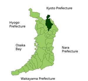
| Location of Takatsukis in Osaka Prefecture | ||
Takatsuki ( Japanese 高 槻 市 , - shi ) is a city in Osaka Prefecture in Japan .
geography
Takatsuki is north of Osaka and southwest of Kyoto .
history
Takatsuki is an old castle town where the Takayama daimyō resided in their Takatsuki castle in the 16th century until they were deposed in 1600. Under the Tokugawa, the Toki, Matsudaira, Okabe, again the Matsudaira and finally from 1649 to 1868 the Nagai with an income of 33,000 Koku resided there .
Takatsuki became a town on January 1, 1943. Due to its location between the major cities of Kyoto and Osaka and its easy accessibility each 13-15 minutes from Takatsuki to Kyoto or Osaka, Takatsuki has experienced a rapid boom in recent decades, especially as a commuter city .
Attractions
traffic
- Street:
- National roads 170, 171
- Train:
- JR Tōkaidō Main Line , between Osaka and Kyōto
- Hankyū Kyōto Line
Town twinning
-
 Changzhou , PR China , since 1987
 -
 Manila , Philippines , since 1979
 -
 Toowoomba , Queensland , Australia , since 1991
sons and daughters of the town
- Yukiko Ishibashi , violinist
- Hayato Nukui (born 1996), soccer player
- Nobunari Oda (* 1987), figure skater
- Tanaka Ryohei , artist
- Takahide Umebachi (* 1992), football player
Neighboring cities and communities
literature
- Papinot, Edmond: Historical and Geographical Dictionary of Japan. Reprinted by Tuttle, 1972 edition of 1910 edition. ISBN 0-8048-0996-8 .
Web links
Commons : Takatsuki - collection of pictures, videos and audio files


