Ōsakasayama
| Ōsaka-Sayama-shi 大阪 狭 山 市 |
||
|---|---|---|
| Geographical location in Japan | ||
|
|
||
| Region : | Kinki | |
| Prefecture : | Osaka | |
| Coordinates : | 34 ° 30 ' N , 135 ° 33' E | |
| Basic data | ||
| Surface: | 11.86 km² | |
| Residents : | 58,746 (October 1, 2019) |
|
| Population density : | 4953 inhabitants per km² | |
| Community key : | 27231-1 | |
| Symbols | ||
| Flag / coat of arms: | ||
| Tree : | cherry | |
| Flower : | azalea | |
| town hall | ||
| Address : |
Osaka-Sayama City Hall 1 - 2384 - 1 , Sayama Osaka-Sayama -shi Osaka 589-8501 |
|
| Website URL: | www.city.osakasayama.osaka.jp | |
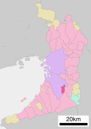
| Location Osaka-Sayamas in Osaka Prefecture | ||
Ōsakasayama ( Japanese 大阪 狭 山 市 , -shi ) is a city in Osaka Prefecture in Japan .
geography
Osaka-Sayama is east of Sakai and southeast of Osaka .
history
The previously existing [district] city of Sayama (Sayama- chō ) became a district-free city (- shi ) on October 1, 1987 , the prefectural name Ōsaka was prefixed to the place name - in Saitama there had been a Sayama-shi since 1954 .
traffic
- Train: Nankai-Koya Line
- Road: National Road 310
Attractions
Not far from the train station is Lake Sayama (sayama-ike), the oldest preserved reservoir in Japan, which was already mentioned in the Nihonshoki . A museum (English name: Osaka Prefectural Sayamaike Museum), built by Tadao Andō , honors the history of the lake with a presentation of excavation finds.
Neighboring cities and communities
Personalities
- Yūki Kotani (born 1991), football player
Web links
Commons : Ōsakasayama - collection of images, videos and audio files


