Izumiotsu
| Izumiōtsu-shi 泉 大 津市 |
||
|---|---|---|
|
|
||
| Geographical location in Japan | ||
| Region : | Kinki | |
| Prefecture : | Osaka | |
| Coordinates : | 34 ° 30 ' N , 135 ° 25' E | |
| Basic data | ||
| Surface: | 12.63 km² | |
| Residents : | 74,566 (October 1, 2019) |
|
| Population density : | 5904 inhabitants per km² | |
| Community key : | 27206-0 | |
| Symbols | ||
| Flag / coat of arms: | ||
| Tree : | Camphor tree | |
| Flower : | Rhododendron indicum | |
| town hall | ||
| Address : |
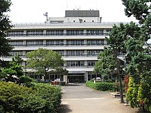
Izumiōtsu City Hall 9 - 12 , Shinonome-chō Izumiōtsu -shi Ōsaka 595-8686 |
|
| Website URL: | http://www.city.izumiotsu.lg.jp/ | |
| Location of Izumiōtsu in Osaka Prefecture | ||
Izumiōtsu ( Japanese 泉 大 津市 , -shi ) is a city in Osaka prefecture in Japan .
geography
Izumiōtsu is located south of Osaka and Sakai .
history
The city of Ōtsu in Semboku County, which had previously belonged to the district , became a district-free city (-shi) on April 1, 1942 . At the same time, the province name Izumi (in the shortened spelling as 泉 ) was prefixed to the place name - in Shiga prefecture / province Ōmi there was an Ōtsu-shi since 1898 . Izumi-Ōtsu was the eighth city in the prefecture.
traffic
- train
- Street:
- National road 26
Neighboring cities and communities
Web links
Commons : Izumiōtsu - collection of images, videos and audio files


