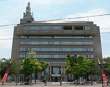
Fujiidera
| Fujiidera-shi 藤井 寺 市 |
||
|---|---|---|
|
|
||
| Geographical location in Japan | ||
| Region : | Kinki | |
| Prefecture : | Osaka | |
| Coordinates : | 34 ° 34 ' N , 135 ° 36' E | |
| Basic data | ||
| Surface: | 8.89 km² | |
| Residents : | 63,814 (October 1, 2019) |
|
| Population density : | 7178 inhabitants per km² | |
| Community key : | 27226-4 | |
| Symbols | ||
| Tree : | Ume | |
| Flower : | Garden chrysanthemum | |
| town hall | ||
| Address : |
Fujiidera City Hall 1 - 1 - 1 , Oka Fujiidera -shi Ōsaka 583-8583 |
|
| Website URL: | http://www.city.fujiidera.osaka.jp | |
| Location of Fujiideras in Osaka Prefecture | ||
Fujiidera ( Japanese 藤井 寺 市 , - shi ) is a city in Osaka Prefecture in Japan .
geography
Fujiidera is northeast of Sakai and southeast of Osaka .
history
Fujiidera was founded on November 1st, 1966 .
Attractions
- AICEL Shura Hall ( ア イ セ ル シ ュ ラ ホ ー ル , Aiseru shura hōru )
-
Buddhist temples:
- Fujii-dera ( 藤井 寺 )
- Dōmyō-ji ( 道明寺 )
- Dōmyō-ji Tenman-gū ( 道明寺 天 満 宮 , Shintō shrine )
Neighboring cities and communities
traffic
- train
- Street:
- National Road 170
Personalities
- Daichi Akiyama (* 1994), soccer player
- Daiki Yamamoto (* 1992), soccer player
Web links
Commons : Fujiidera - collection of images, videos and audio files


