Chulitna River (Susitna River)
| Chulitna River | ||
|
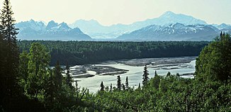
Chulitna River in the foreground, the Alaska Range in the background |
||
| Data | ||
| Water code | US : 1400392 | |
| location | Alaska (USA) | |
| River system | Susitna River | |
| Drain over | Susitna River → Pacific Ocean | |
| Confluence of |
Middle Fork and East Fork Chulitna River 63 ° 6 ′ 31 ″ N , 149 ° 31 ′ 24 ″ W |
|
| Source height | 486 m | |
| muzzle |
Susitna River Coordinates: 62 ° 20 ′ 8 " N , 150 ° 9 ′ 1" W 62 ° 20 ′ 8 " N , 150 ° 9 ′ 1" W |
|
| Mouth height | 107 m | |
| Height difference | 379 m | |
| Bottom slope | 3.4 ‰ | |
| length | 110 km | |
| Catchment area | approx. 6600 km² | |
| Discharge A Eo : 6526 km² Location: 26 km above the mouth |
MQ 1959/1985 Mq 1959/1985 |
250 m³ / s 38.3 l / (s km²) |
| Right tributaries | West Fork Chulitna River, Ohio Creek, Fountain River, Hidden River, Coffee River, Tokositna River | |
| West Fork Chulitna River | ||
| Water code | US : 1411863 | |
| origin |
West Fork Glacier 63 ° 16 ′ 21 ″ N , 149 ° 59 ′ 44 ″ W |
|
| Source height | approx. 950 m | |
| muzzle | Chulitna River 63 ° 3 ′ 11 " N , 149 ° 35 ′ 46" W. |
|
| Mouth height | 432 m | |
| Height difference | approx. 518 m | |
| Bottom slope | approx. 12 ‰ | |
| length | 45 km | |
| Left tributaries | Bell River | |
| Middle Fork Chulitna River | ||
| Water code | US : 1406292 | |
| source | 10 km south of Cantwell , 7 km north of Caribou Pass 63 ° 18 ′ 25 ″ N , 148 ° 50 ′ 9 ″ W |
|
| Source height | 1500 m | |
| Association with | East Fork Chulitna River 63 ° 6 ′ 32 " N , 149 ° 31 ′ 29" W. |
|
| Mouth height | 486 m | |
| Height difference | 1014 m | |
| Bottom slope | approx. 20 ‰ | |
| length | approx. 50 km | |
| East Fork Chulitna River | ||
| Water code | US : 1401578 | |
| source | 18 km south of Caribou Pass 63 ° 4 ′ 26 ″ N , 148 ° 48 ′ 21 ″ W |
|
| Source height | approx. 1350 m | |
| Association with | Middle Fork Chulitna River 63 ° 6 ′ 32 " N , 149 ° 31 ′ 24" W. |
|
| Mouth height | 486 m | |
| Height difference | approx. 864 m | |
| Bottom slope | approx. 17 ‰ | |
| length | 50 km | |
The Chulitna River is an approximately 110 km long right tributary of the Susitna River in southern Alaska .
It arises from the confluence of the Middle and East Fork Chulitna Rivers in the valley between the Alaska Range and Talkeetna Mountains east of Denali , flows south and flows into the Susitna River at Talkeetna , opposite the Talkeetna River , which flows into the Cook Inlet . Major tributaries are West Fork Chulitna River , Ohio Creek , Fountain River , Hidden River , Coffee River, and Tokositna River , all from right. The catchment area of the Chulitna River covers approximately 6600 km². The mean discharge not far from the mouth is 250 m³ / s. The highest monthly outflows of the river, which is mainly fed by the meltwater from the glaciers, occur in the months of June to August.
The George Parks Highway from Anchorage to Fairbanks runs parallel to the entire course of the river.
The native Alaskan name for the river was documented by GH Eldridge in 1898.
