
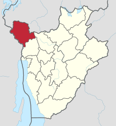
Cibitoke Province
| Cibitoke | |
|---|---|
  |
|
| Basic data | |
| Country | Burundi |
| Capital | Cibitoke |
| surface | 1,635.5 km² |
| Residents | 523,000 (calculation 2007) |
| density | 320 inhabitants per km² |
| ISO 3166-2 | BI-CI |
Coordinates: 2 ° 53 ′ S , 29 ° 7 ′ E
Cibitoke is the north-westernmost province of Burundi . Their capital is also called Cibitoke .
The population density in 1990 was 150 to 200 inhabitants per km², in 2007 the province has an estimated 523,000 inhabitants.
Cibitoke borders Rwanda and the Democratic Republic of the Congo . The landscape in the east is characterized by tropical mountain forests. In the north and west there is a lot of grass savannah, some with forest islands. Cibitoke is a particularly fertile province with goat farming and the cultivation of cotton, coffee, bananas and peanuts. There are gold and oil deposits in natural resources, and there is also some tobacco-processing industry.
Cibitoke is divided into the six districts of Buganda , Bukinanyana , Mabayi , Mugina , Murwi and Rugombo .
swell
- ↑ Page no longer available , search in web archives: bevölkerungsstatistik.de (2007)
- ^ Map of Cibitoke