
Muyinga (Province)
| Muyinga | |
|---|---|
  |
|
| Basic data | |
| Country | Burundi |
| Capital | Muyinga |
| surface | 1,836.3 km² |
| Residents | 627,000 (calculation 2007) |
| density | 341 inhabitants per km² |
| ISO 3166-2 | BI-MY |
Coordinates: 2 ° 49 ′ S , 30 ° 19 ′ E
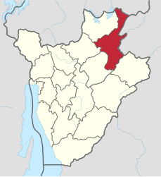
Muyinga (alternative spelling Muhinga ) is a province of Burundi . It is located in the northeast of the country and borders on Rwanda in the north and Tanzania in the east . The provincial capital is also called Muyinga .
In 2007, Muyinga has a population of around 627,000.
Muyinga is divided into the seven districts ( communes ) Buhinyuza , Butihinda , Gashono , Gasorwe , Giteranyi , Muyinga, and Mwariko .
swell
- ↑ bevölkerungsstatistik.de (2007)
- ^ Map of Muyinga