Ciudad de Cuetzalan
| Ciudad de Cuetzalan | ||
|---|---|---|
|
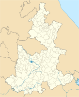
Coordinates: 20 ° 1 ′ N , 97 ° 31 ′ W Ciudad de Cuetzalan on the map of Puebla
|
||
| Basic data | ||
| Country | Mexico | |
| State | Puebla | |
| Municipio | Cuetzalan del Progreso | |
| Residents | 5957 (2010 census) | |
| City insignia | ||
| Detailed data | ||
| height | 932 m | |
| Time zone | UTC −6 | |
| Website | ||
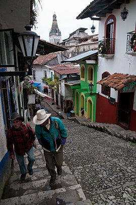
| Cuetzalan del Progreso - Alley and spire of the Iglesia San Francisco de Asís | ||
Ciudad de Cuetzalan is a city with about 6000 inhabitants and the capital of the Municipio Cuetzalan del Progreso with a total of about 45,000 inhabitants in the Mexican state of Puebla . The city has been one of the so-called Pueblos Mágicos since 2002 .
location
Ciudad de Cuetzalan is located in the Sierra Norte de Puebla at about 930 m above sea level. d. M. and is about 175 km (driving distance) in a north-easterly direction from the city of Puebla . It is about 65 km (as the crow flies) to the coast of the Gulf of Mexico . The Yohualichan Archaeological Zone is 8 km to the north.
population
About two thirds of the population are Indians of different tribal groups; about a third are mestizos . The majority of the rural villages speak Nahuatl , but most of the people in the city also speak Spanish.
economy
Agriculture and cattle breeding are practiced on the fertile soils in the surrounding area; There are also several coffee plantations here . The city itself served as a market place as well as a trade, handicraft and service center.
history
As the archaeological site of Yohualichan proves, the area was already settled in pre- Hispanic times. In 1485 the entire region came under the control of the Aztec Empire ; the Aztec name was Quetzallan , which may indicate that the tribute was paid in the form of feathers or feather ornaments - the bird in the city's coat of arms ties in with this tradition. The Spaniards conquered the place in 1522, and the monks of the Franciscan order who arrived here about 30 years later built the first church in the 16th century, which was later renovated in baroque style and in the late 19th century, when the place was granted city rights were (1895), received a new west facade.
Attractions
- Some alleys and buildings around the central square ( parque central ) still show a colonial flair.
- The most important buildings in the city are located in the central square. The unadorned clock tower ( torre de reloj ) is considered by many to be the only remnant of the town's first church.
- The church of San Francisco de Asís , built in the strict baroque style, dates from the 17th century; At the end of the 19th century it was given a powerful neo-Romanesque facade with a 68 m high central tower. The three-aisled and vaulted nave ends under an illuminated crossing dome . Behind the altar rises an imposing canopy dome resting on channeled columns with a final cross, which hides the tabernacle .
- In the Capilla de la Purísima Concepción (called La Conchita ) built in the years after 1880 , playful neo-baroque style elements emerge more clearly. The graceful tower and the keel-arched gable are remarkable .
- The Iglesia de los Jarritos of the Santuario de Guadalupe is a neo-Gothic building that was completed in 1895 and is located in the municipality's cemetery. The interior of the church houses a painting of the Virgin of Guadalupe .
- In the former town hall ( palacio municipal ) at Parque Central there is an ethnological museum.
- Surroundings
- There are several idyllically situated waterfalls ( cascadas ) and rock grottos ( grutas ) in the water-rich surroundings of the place .
- The pre-Hispanic cult center of Yohualichan contains several temple pyramids ; the two largest each have a central staircase slightly protruding from the stepped structure with side walls. The temples formerly at the top may have been destroyed by human hands due to the forces of nature. The buildings of the complex are clearly in the succession of the Totonak niche pyramid of El Tajín located about 50 km (as the crow flies) north .
Festivals
Every year in the first week of October, around the feast day of the city's patron saint Francis of Assisi , the spectacle of the Voladores takes place in the central square of the city , in which four young men, whose ankles are wrapped with ropes, rise from the top of a 31 m high Mastes - supposedly the tallest in all of Mexico - fall down. Since the ropes were previously wrapped around the mast, the men slowly turn their heads downwards, as if floating or flying, down to the ground. A fifth person stands on the top of the mast, which is only about 30 cm in length, and plays the flute.
Web links
- Enciclopedia de los Municipios y Delegaciones de México: Cuetzalan, history etc. - information (Spanish)


