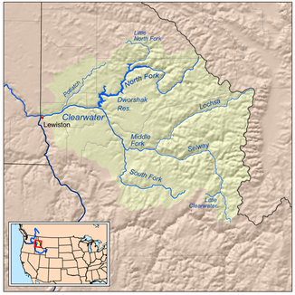
Clearwater River, Idaho
| Clearwater River | ||
|
Clearwater River catchment area |
||
| Data | ||
| Water code | US : 379406 | |
| location | Idaho (USA) | |
| River system | Columbia River | |
| Drain over | Snake River → Columbia River → Pacific Ocean | |
| Confluence of |
Middle Fork and South Fork Clearwater River 46 ° 8 ′ 45 ″ N , 115 ° 58 ′ 57 ″ W |
|
| Source height | 373 m | |
| muzzle | at Lewiston in the Snake River coordinates: 46 ° 25 '30 " N , 117 ° 2' 14" W 46 ° 25 '30 " N , 117 ° 2' 14" W. |
|
| Mouth height | 226 m | |
| Height difference | 147 m | |
| Bottom slope | 1.2 ‰ | |
| length | 120 km | |
| Catchment area | 24,980 km² | |
| Drain |
MQ |
433 m³ / s |
| Right tributaries | North Fork Clearwater River , Potlatch River | |
| Small towns | Orofino | |
|
Clearwater River at Greer, Idaho |
||
|
Clearwater River at Orofino, Idaho |
||
| North Fork Clearwater River | ||
| Water code | US : 387675 | |
| location | Idaho (USA) | |
| River system | Columbia River | |
| Drain over | Clearwater River → Snake River → Columbia River → Pacific Ocean | |
| source | near Illinois Peak 47 ° 0 '11 " N , 115 ° 6' 16" W |
|
| muzzle |
Clearwater River 46 ° 30 ′ 0 ″ N , 116 ° 19 ′ 50 ″ W. |
|
| Mouth height |
299 m
|
|
| Right tributaries | Little North Fork Clearwater River | |
| Reservoirs flowed through | Dworshak Dam | |
| Middle Fork Clearwater River | ||
| Water code | US : 386806 | |
| location | Idaho (USA) | |
| River system | Columbia River | |
| Drain over | Clearwater River → Snake River → Columbia River → Pacific Ocean | |
| Confluence of |
Lochsa River and Selway River 46 ° 8 ′ 25 ″ N , 115 ° 35 ′ 58 ″ W. |
|
| Association with | South Fork Clearwater River to Clearwater River 46 ° 8 ′ 44 ″ N , 115 ° 58 ′ 57 ″ W |
|
| Mouth height |
373 m
|
|
| length | 38 km | |
| National Wild and Scenic River | ||
| South Fork Clearwater River | ||
| Water code | US : 390908 | |
| location | Idaho (USA) | |
| River system | Columbia River | |
| Drain over | Clearwater River → Snake River → Columbia River → Pacific Ocean | |
| source | near Red River Hot Springs 45 ° 48 ′ 30 ″ N , 115 ° 28 ′ 29 ″ W. |
|
| Union | with Middle Fork Clearwater River to Clearwater River 46 ° 8 ′ 45 ″ N , 115 ° 58 ′ 57 ″ W |
|
| Mouth height |
373 m
|
|
The Clearwater River ( English for "clear water river") is a 120 km long river in the US state of Idaho .
It flows from the mountains of the Rocky Mountains west through northern Idaho. The Clearwater flows into the Snake River at Lewiston .
The Middle Fork Clearwater River and its two headwaters, the Lochsa River and the Selway River, are protected as a National Wild and Scenic River .
The South Fork Clearwater River joins in Kooskia with the Middle Fork Clearwater River to Clearwater River .
The North Fork Clearwater River is dammed near Orofino in the Dworshak Dam . Coming from the right, it flows into the Clearwater River.
history
In September 1805, the Lewis and Clark Expedition followed an Indian trail along the river and met the Nez Percé Indians near what is now the town of Weippe . The name Clearwater is the English translation of a term from the language of the Nez Percé: Koos-Koos-Kai-Kai means clear water. At Clearwater it came in 1877, as part of the Nez Percé campaign, also to the "Battle of Clearwater".
Web links
Individual evidence
- ↑ a b Middle Fork Clearwater River in the Geographic Names Information System of the United States Geological Survey
- ^ Clearwater River in the Geographic Names Information System of the United States Geological Survey
- ^ North Fork Clearwater River in the Geographic Names Information System of the United States Geological Survey
- ↑ South Fork Clearwater River in the Geographic Names Information System of the United States Geological Survey
- ^ Middle Fork of the Clearwater River. ( Memento of the original from March 9, 2012 in the Internet Archive ) Info: The archive link was inserted automatically and has not yet been checked. Please check the original and archive link according to the instructions and then remove this notice. National Wild & Scenic Rivers


