Clyde (New Zealand)
| Clyde | ||
| Geographical location | ||
|
|
||
| Coordinates | 45 ° 11 ′ S , 169 ° 19 ′ E | |
| Region ISO | NZ-OTA | |
| Country |
|
|
| region | Otago | |
| District | Central Otago District | |
| Ward | Alexandra Ward | |
| Local foundation | 1860s | |
| Residents | 1 011 (2013) | |
| height | 160 m | |
| Post Code | 9330 | |
| Telephone code | +64 (0) 3 | |
| UN / LOCODE | NZ CLY | |
| website | www.clyde.co.nz | |
| Photography of the place | ||
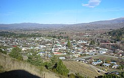
 Look at Clyde |
||
Clyde is a small town in the Central Otago District of the Otago Region on the South Island of New Zealand .
Origin of name
The place was named on May 22, 1865 after Colin Campbell, 1st Baron Clyde .
geography
Clyde is about 8 km northwest of Alexandra on the Clutha River . The New Zealand State Highway 8 , which connects Alexandra in the southeast and Cromwell in the northwest with Clyde, runs directly through the town.
The local climate is particularly warm and dry in the summer months, as Clyde lies in the rain shadow of the southern Alps for the prevailing westerly winds .
population
In the 2016 census, the town had 1,011 inhabitants, 9.8% more than in the 2006 census.
history
Clyde emerged from the earlier settlement of Dunstan during the Otago gold rush of the 1860s . After the American Horatio Hartley and the Irish Christopher Reilly found gold on the Clutha River, they initially kept the location a secret. But after they wanted to exchange 87 pounds of gold in Dunedin , the Otago Province Council offered them 2000 pounds sterling if they would name the location. They accepted the deal, and so throngs of gold miners moved to the area to find their fortune. In a short time the population rose to over 4000 and in the first year they mined 70,000 ounces of gold. In 1864 the easily digested gold was exhausted. So gold prospectors got together, founded companies and were able to finance more complex extraction methods with the collected capital. Clyde was the most populous place in New Zealand during the height of the gold rush.
Today the name of the place is associated with its hydroelectric power station, as the great Clyde Dam is at the north end of the place. This dams the Clutha River to Lake Dunstan .
The place today
The place is a resort and is located at the west end of the Otago Central Rail Trail . The trail follows the route of the former Otago Central Railway , which originally extended to Cromwell. The section from Clyde was closed for passenger traffic in 1980 and only used for the transport of materials for the construction of the dam. In 1990 the line was completely discontinued.
There is a hospital in the village, the Dunstan Hospital , which also serves the care of the surrounding area including Alexandra and Cromwell. It moved to a new building in 2006. Clyde has a primary school, the next secondary school is in Alexandra, 10 km away. The nearest university is 200 km away in Dunedin .
There are numerous vineyards and orchards in the area.
Events
In late September, the area around Clyde and Alexandra hosts the Spring Festival Blossom Festival . At this time, many fruit trees bloom in the surrounding plantations. In addition to a parade, there is a folk festival and drag races .
Personalities
See also
literature
- Helga Neubauer: Clyde . In: The New Zealand Book . NZ Visitor Publications, Nelson 2003, ISBN 1-877339-00-8 , pp. 847 f .
Web links
- Homepage. Promote Dunstan, accessed August 9, 2014 .
Individual evidence
- ↑ a b 2013 Census QuickStats about a place: Clyde. Statistics New Zealand, accessed June 2, 2017 .
- ↑ Topo250 maps. Land Information New Zealand, accessed June 3, 2017 .
- ↑ Clyde . In: The New Zealand Book . 2003, p. 848 .
