
Col de Banyuls
| Col de Banyuls | |||
|---|---|---|---|
 View of the pass with a boundary stone in the foreground |
|||
| Pass height | 361 m | ||
| Department | Pyrénées-Orientales , France | ||
| Valley locations | Banyuls-sur-Mer | Espolla | |
| Mountains | Pyrenees | ||
| Map (Pyrénées-Orientales) | |||
|
|||
| Coordinates | 42 ° 27 '0 " N , 3 ° 3' 14" E | ||

The Col de Banyuls , in Catalan Coll de Banyuls , is a 361 meter high mountain pass in the Serra de l'Albera , which connects Catalonia with northern Catalonia . The French-Spanish border runs over it.
Toponymy
The Col de Banyuls was formerly called Col d'Espils or Coll d'Espils . His name was then transferred to the two settlements below the pass: Les Abeilles on the French side and Espolla on the Spanish side. The word Espils is likely derived from the Latin specula and refers to a watchtower ( turris speculatoria ).
Geographical location
Alongside the Col du Perthus and the Coll dels Belitres , the Col de Banyuls is one of the three road passes in the Albères massif. It connects the French municipality of Banyuls-sur-Mer ( Banyuls de la Marenda in Catalan ) in the Pyrénées-Orientales department , located on the Mediterranean Sea , with the Spanish municipality of Espolla, which belongs to the Catalan comarca of Alt Empordà . The Spanish side directly at the top of the pass, however, is in the area of the municipality of Rabós .
The pass crosses the Albères massif at an altitude of 361 meters. Topographically, it forms the depression between the 713 meter high Puig de la Calma in the southeast and the 699 meter high Pic Estela in the northwest. From Banyuls-sur-Mer it is 10 kilometers to the top of the pass, with the road (Route des Mas) following the Baillaury river uphill to the southwest. From Espolla on the Catalan side it is 11 kilometers, here the road (Carrer de Banyuls) follows the valley of the Orlina to the northeast.
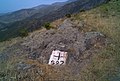
Immediately on the south side of the pass crossing is the border marker N ° 591. A water storage tank is installed further back . The border cross N ° 592 then follows further to the south-east on the ridge. On the north side of the pass crossing there is a notice board about the cross-border fire hazard, together with a wooden board about a fire containment project. On the same side a little further back is a former bunker, which is now used as a refuge by the Center Excursionista Empurdanès .
On the French side, on the left below the top of the pass, General Charles de Gaulle had a memorial erected for the liberation of France by the Resistance in June 1944 . There are also three signs commemorating the Spanish Civil War (1936 to 1939) and the subsequent Retirada .
The pass is a popular starting point for excursions into the Albères massif. It is also an excellent point of view of the Côte Vermeille . From the Alt Empordà plain in the south, the Col de Banyuls can be seen from practically anywhere.
geology
The geological subsoil of the Col de Banyuls is made up of Paleozoic schists from the Albères massif . The rocks metamorphosed towards the end of the Variscan orogeny in the Upper Carboniferous around 300 million years ago BP are older than 470 million years. They are relatively low metamorphic and belong to the chlorite zone of the green schist facies .
history
The Col de Banyuls has a long history that probably goes back to ancient times . It is very likely that the Via Heraclea ran over it and possibly also a branch of the Via Domitia .
Under General Antonio Ricardos , the Spanish troops attempted an invasion of Roussillon (War of Roussillon) in 1793 , but encountered bitter resistance from the local population in the Battle of Col de Banyuls.
Photo gallery

Resistance memorial from June 1944

Panel in memory of the Retirada

Refuge of the CEE

Information panel on the cross-border fire risk
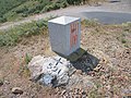
Border cross N ° 591
Border cross N ° 592

water-tank
Driveway to the Col from the Catalan side (Espolla)
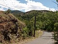
Driveway from the French side (Banyuls-sur-Mer)


literature
- Becat, Joan: 12-Banyuls de la Marenda . In: Atles toponímic de Catalunya Nord. I. Aiguatèbia - Montner . Terra Nostra (Biblioteca de Catalunya Nord, XVIII), 2015, ISSN 1243-2032 .
- Becat, Joan, Ponsich, Pere and Gual, Raimon: Banyuls de la Marenda, Cotlliure i Portvendres . In: El Rosselló i la Fenolleda . Barcelona: Fundació Enciclopèdia Catalana (Gran Geografia Comarcal de Catalunya, 14) 1985, ISBN 84-85194-59-4 .
Individual evidence
- ↑ Lluís Basseda: Toponymie historique de Catalunya Nord, t. 1 . In: Revista Terra Nostra . Prades 1990, p. 796 .
- ↑ Jean Sagnes: Le pays catalan, t. 2 . Société nouvelle d'éditions régionales, Pau 1985, ISBN 2-904610-01-4 , p. 579-1133 .