Düffelward
|
Düffelward
City of Kleve
|
|
|---|---|
| Coordinates: 51 ° 49 ′ 43 ″ N , 6 ° 6 ′ 28 ″ E | |
| Height : | 13 m |
| Area : | 2.71 km² |
| Residents : | 616 (December 31, 2015) |
| Population density : | 227 inhabitants / km² |
| Postal code : | 47533 |
| Area code : | 02821 |
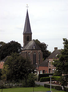
Düffelward is located on the Lower Rhine in the northwest of North Rhine-Westphalia and is a district of the city of Kleve . The district has 616 inhabitants (as of December 31, 2015) on an area of 271 hectares. The village is located in the Düffel , the part of the name -ward for a bank area drained by means of a dike (Dutch waard ) is common on the Lower Rhine.
history
Düffelward is at a fork in the Roman road from Xanten to Nijmegen . Numerous finds remind of the Roman past of the place near the Römerlage cattle . The village belonged to the Franconian office of Düffel , which was initially headed by a count . The parish had existed since at least 1205. In the Thirty Years' War in 1636 the village was destroyed during the fighting over Schenkenschanz , as was the original church. The ruins of the St. Mauritius Church were replaced by a neo-Gothic building in 1851.
In the nearby Reichswald and in the vicinity of today's town, the so-called battle in the Reichswald raged in the spring of 1945 , which severely affected the town.
Düffelward belonged to the Keeken office since 1800 , which became the cattle office in 1945. 1969 Düffelward was incorporated into the city of Kleve.
The parishes Bimmen St. Martin, Düffelward St. Mauritius, St. Keeken Assumption and cattle St. Willibrord 2005 were combined into one parish with the joint parish church in cattle.
The ferry to Schenkenschanz was discontinued in 2016.
Individual evidence
- ↑ a b Kleve in brief. In: kleve.de. Retrieved April 23, 2019 .
- ^ Also Wardhausen , Emmericher Ward , Dornicker Ward .


