Schenkenschanz
|
Schenkenschanz
City of Kleve
Coordinates: 51 ° 50 ′ 10 ″ N , 6 ° 6 ′ 37 ″ E
|
|
|---|---|
| Residents : | 102 (December 31, 2015) |
| Postal code : | 47533 |
| Area code : | 02821 |
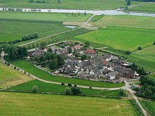
Schenkenschanz is a district of the city of Kleve and is located on the Lower Rhine in the northwest of North Rhine-Westphalia . Schenkenschanz has almost 100 inhabitants (as of 2016).
geography
Schenkenschanz is located around five kilometers north of the center of the city of Kleve between the Rhine and the Griethausen Old Rhine , which flows into the Rhine 2.5 km below the village.
Location and appearance
The Schenkenschanz district is the smallest district of Kleve with 38 hectares . Nine tenths of the place are in the floodplain of the Kleve- Salmorth nature reserve , one tenth is built on. Two thirds of the place are protected by a flood protection wall, the rest is protected from flooding by a dike .
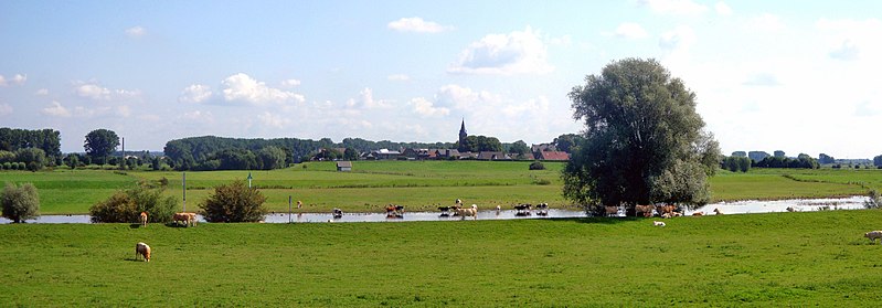
The Rhine at Schenkenschanz
The entire history of the area around Schenkenschanz has been in the area of influence of the Rhine with floods, bank breaks, island formation and relocations. The drawing by the cartographer Johann Bucker shows that the place with the former fortifications in 1713 was still located at the junction of the Waal and Nederrijn . There are also some former islands and sands (e.g. Fridericks Wardt and Salmorth ). Today Salmorth is the foreland to the villages of Griethausen , Brienen and Düffelward . After hydraulic engineering work in the 18th century, the river no longer divides at Schenkenschanz, but only further north on Dutch territory into the Waal and Nederrijn rivers.
Schenkenschanz used to be regularly surrounded by the spring floods of the Rhine. Today there are only sporadic storm floods.
Transport links
Since April 2016, the place can only be reached by land over the Altrheinbrücke in Kleve-Griethausen, the lowest point on the access route to the following four-kilometer-long Deichstraße. The former ferry connection over the Griethausen Altrhein to Düffelward was discontinued by the city of Kleve after 111 years.
history


The place owes its origin to the Eighty Years War between the Netherlands and Spain. In 1579 seven Dutch provinces united to form the Union of Utrecht against Spain. They refused to obey the Spaniards. They also made pacts with England: Queen Elizabeth I supported them with money and soldiers through Robert Dudley . In 1586/87, the Lord had a fortress built by Field Captain Martin Schenk von Nideggen in the corner of the then fork of the Rhine and Waal , on a large and swampy headland known as "'s Grevenward", "Saarbrugg" or "Fuchsenloch" . At the end of the 16th century, the fortress was one of the strongest in Europe. It was of great importance and as the gateway to the Netherlands was long considered impregnable.
The strategic importance becomes clearer when looking at the topographical situation at that time : The splitting of the Rhine into a southern Waal and a northern branch of the mouth, the Nederrijn (more precisely: Pannerdens Canal ), occurs today about 7.5 km west (downstream) of Schenkenschanz Millingen on the Rhine . Before the Schenkenschanz fortress was built, however, this was about 5 km further upstream, about at the height of today's Griethausen . The old Rhine there is still reminiscent of this today as the remainder of the former river course. Thus, the land on which Schenkenschanz was built formed an upstream headland, also called Spyck . Even today there is Spyck as a field name north of Griethausen, here is an industrial oil mill. By shifting the rivers below Schenkenschanz, the fortress became an island from which both rivers could be controlled. Schenkenschanz was therefore nicknamed the guardian of both rivers . During the Spanish-Dutch war, for example, the site was the scene of constant military conflicts and was repeatedly bombed, set on fire and looted. Even with the end of the war and the recognition of the independence of the United Netherlands in 1648, the dispute over the village was not over. At the beginning of the Dutch War (see also: Description of the course of the war ), in 1672 the 34-year-old French King Louis XIV stood personally with his troops at the gates. After a battle, the 21-year-old commander had to capitulate. On May 1, 1674, the French withdrew and the troops of Kurbrandenburg moved in . They remained until the end of the war in 1679. Schenkenschanz then became Dutch again.
At the end of the 17th century, the Lower Rhine increasingly silted up and the water flowed more and more into the Waal. In 1702 the Dutch government dug a canal from the Waalbett to the Nederrijn there near Millingen (the Pannerdens Canal) to give the Nederrijn a stronger current. As a result, Schenkenschanz was drained and lost its strategic and military importance. The fortress, which was fiercely contested for many decades, then developed into a peaceful and quiet place.
From 1794/98 onwards, Schenkenschanz formed a rural community in the Griethausen mayor's office in the Kleve district . The sovereignty changed from the Netherlands to Prussia in 1817 in exchange for Leuth and Kekerdom . By a Prussian government decree, the community of Schenkenschanz was incorporated into the community of Salmorth in 1911 . As part of Salmorth, Schenkenschanz came to the city of Kleve in 1969, where it received the status of its own district.
timeline
- 1586: Martin Schenk expands the place into a fortress on behalf of Robert Dudley , Earl of Leicester .
- 1634: the Protestant church is built.
- 1636: The Schenkenschanz is besieged by Prince Frederik Hendrik of Orange .
- 1674: The Schenkenschanz becomes Dutch.
- 1816: The place comes to Prussia , the fortress is razed .
- 1911: The community of Schenkenschanz is incorporated into the community of Salmorth.
- July 1, 1969: The municipality of Salmorth is incorporated into Kleve.
- February 1995: The Rhine flood surrounds Schenkenschanz. The place needs to be evacuated.
- April 1, 2016: The previous ferry connection is discontinued by the city of Kleve and the infrastructure is dismantled.
village life
Despite the small size of the village, a lively club life has developed. B. a homeland club, a rifle club, a marines marching band and a soccer club founded in 1906, which, however, merged with the Kleve-Düffelward soccer club in the 1980s.
gallery
War memorial with the inscription: "Your fallen brothers - the village of Schenkenschanz"
Schenkenschanz in film and in literature
- Schenkenschanz is the central location of the film The Garden of Eden by Lutz Mommartz from 1977. The Garden of Eden , accessed on September 3, 2016.
- Schenkenschanz is the central location of the thriller Die Schanz , published by Rowohlt Verlag in 2004, by the Leenders / Bay / Leenders trio of authors .
- It is mentioned by Hans-Dieter Hüsch in the volume of poetry “ Am Niederrhein ” (1984, p. 31): “Schenkenschanz. Give me a name. And I'll make a story out of it for you. ... Schenkenschanz. It must be a place full of fools. I thought as a child. I still think so today. Because I've never been there "
literature
- G. Leibold: Schenkenschanz. A painting of three centuries of clever history. In: Clever Kreisblatt. 1906. Second reprint 1985: GW Bösmann: Kleve.
- Guido de Werd : Schenkenschanz. Boss, Kleve 1986, ISBN 3-922384-48-X .
- Karl Kossert: Martin Schenk von Nideggen. Mercator, Duisburg, 1993, ISBN 3-87463-196-6 .
- German villages rediscovered. Das Beste, Stuttgart 1985, ISBN 3-87070-242-7 .
Individual evidence
- ↑ Kleve in brief. In: kleve.de. Retrieved April 23, 2019 .
- ↑ Erich Wisplinghoff, explanations from 1984 on: Johann Bucker, map of the Rhine from Duisburg to Arnheim from 1713, publisher: Nordrhein-Westfälisches Staatsarchiv, Düsseldorf 1984, p. 5–10.
- ^ Community encyclopedia for the province of Rhineland 1885
- ^ Dieter Echterhoff, Claudia Kressin: Fährgeschichte von Schenkenschanz. (PDF) In: Schänzer Bötchen No. 8. Heimatverein Schenkenschanz, December 2013, p. 5 , accessed on June 6, 2014 .
- ↑ Martin Bünermann: The communities of the first reorganization program in North Rhine-Westphalia . Deutscher Gemeindeverlag, Cologne 1970.
- ↑ The Schanz on rowohlt.de
Web links
- City of Kleve: Schenkenschanz district
- Current website of Schenkenschanz
- Adam Frans van der Meulen : Picture from Schenkenschanz 1672 at the Rhine crossing of Ludwig XIV.
- Historical map as a digitized edition of the University and State Library Düsseldorf
- Illustration by Frans Hogenberg from 1599: The Schencken Schantz a fäster ordt, Licht auff des Reins and Wallen bort, ... ( digitized )


