Delecke
|
Delecke
municipality Möhnesee
Coordinates: 51 ° 29 ′ 24 ″ N , 8 ° 5 ′ 28 ″ E
|
|
|---|---|
| Height : | 226 m |
| Area : | 22.51 km² |
| Residents : | 633 (December 31, 2017) |
| Population density : | 28 inhabitants / km² |
| Incorporation : | 1st July 1969 |
| Postal code : | 59519 |
| Area code : | 02924 |
|
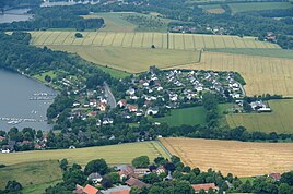
Aerial photograph (2014)
|
|
Delecke is a district of the municipality Möhnesee in the district of Soest , North Rhine-Westphalia .
description
The place is west of Körbecke and east of Günne on the north shore of the Möhnesees . With a total area of 22.5 km², the Delecke district is the largest in the Möhnesee community. It extends from the Haarstrang in the north over the Möhnesee to the district border in the Arnsberg Forest .
The Drüggelte farmers are part of Delecke. The Drüggelter Chapel is well known .
Westrich is integrated into the local community Delecke-Westrich-Drüggelte, but a separate district of Möhnesee.
Delecke is a tourist town with two campsites, one of which has a public bathing area, two yacht clubs and a diving bay.
history
The village was first mentioned in 1191 as Delik . Drüggelte was first mentioned in 1217 as Druglette . The Drüggelter Chapel probably dates from the 12th century.
The Möhne reservoir was built between 1908 and 1912. Since parts of Delecke were flooded when the dam was flooded, 400 of the 670 inhabitants at that time had to be resettled. As a result, Delecke lost its center and established structures were destroyed.
The Bismarck Tower was built on the Haarstrang in 1912 at the highest point of the place (256 m above sea level) .
On September 1, 1925, the place Kettlersteich was incorporated.
At the end of the Second World War , the Deleck Viaduct was blown up on April 8, 1945 by Wehrmacht soldiers fleeing from the advancing American troops. This interrupted the important road connection from Soest via Delecke to Arnsberg . A prestressed concrete bridge was built on the old foundations in 1952, closing the gap again.
On July 1, 1969, Delecke was incorporated into the municipality of Möhnesee.
Rebuilding
The construction areas Am Sonnenhang , Krummer Weg and Am Soestdorn , which were newly designated in the 1970s, encouraged the development of residential houses and the population increased.
Individual evidence
- ↑ Möhnesee community: Population statistics , accessed on March 6, 2018
- ↑ Stephanie Reekers: The regional development of the districts and communities of Westphalia 1817-1967 . Aschendorff, Münster Westfalen 1977, ISBN 3-402-05875-8 , p. 225 .
- ↑ Martin Bünermann: The communities of the first reorganization program in North Rhine-Westphalia . Deutscher Gemeindeverlag, Cologne 1970, p. 91 .


