Alto Saposoa District
| Alto Saposoa District | |
|---|---|
 The district of Alto Saposoa is located in the north of the province of Huallaga (marked in red) |
|
| Basic data | |
| Country | Peru |
| region | San Martín |
| province | Huallaga |
| Seat | Pasarraya |
| surface | 1378 km² |
| Residents | 4685 (2017) |
| density | 3.4 inhabitants per km² |
| founding | September 13, 1963 |
| ISO 3166-2 | PE-SAM |
| Website | munialtosaposoa.gob.pe (Spanish) |
| politics | |
| Alcalde District | Elmer Yoni Garcia Olivera (2019-2022) |
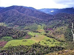
| Landscape in the west of the district | |
Coordinates: 6 ° 46 ′ S , 76 ° 49 ′ W
The Alto Saposoa district is located in the Huallaga province in the San Martín region in northern Peru . The district founded on September 13, 1963 has an area of 1378 km². The 2017 census counted 4685 inhabitants. In 1993 the population was 1792, in 2007 it was 2643. The district administration is located in the 420 m high village of Pasarraya with 1456 inhabitants (as of 2017). Pasarraya is located 20 km north of the provincial capital Saposoa .
Geographical location
The Alto Saposoa district extends over the north of the Huallaga province. The longitudinal extent in NNW-SSE direction is about 82 km, the maximum width about 25 km. The district extends over the upper catchment area of the Río Saposoa . This flows through the district in a south-southeast direction. The district is flanked in the east and west by mountain ranges that are part of the Peruvian Eastern Cordillera .
The Alto Saposoa district is bordered to the south and southwest by the Saposoa district , to the west by the Pachiza and Huicongo districts (both in the Mariscal Cáceres province ), and to the extreme northwest by the Omia and Vista Alegre districts (both in the Rodríguez de Mendoza province ), in the north to the Soritor district ( Moyobamba province ), in the east to the districts of San Martín , San José de Sisa , Agua Blanca and Santa Rosa (all four in the province of El Dorado ) and in the extreme southeast to the San Pablo district ( Bellavista Province ).
Individual evidence
- ^ A b Peru: San Martín - Provinces & Districts . www.citypopulation.de. Retrieved May 26, 2020.
