Soritor District
| Soritor District | |
|---|---|
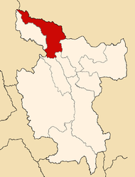
 The Soritor District is located in the southwest of the Moyobamba Province (marked in red) |
|
| Basic data | |
| Country | Peru |
| region | San Martín |
| province | Moyobamba |
| Seat | Soritor |
| surface | 387.8 km² |
| Residents | 21,514 (2017) |
| density | 55 inhabitants per km² |
| founding | January 2, 1857 |
| ISO 3166-2 | PE-SAM |
| Website | munisoritor.gob.pe (Spanish) |
| politics | |
| Alcalde District | Segundo Wilson Ortiz Chávez (2019-2022) |
Coordinates: 6 ° 8 ′ S , 77 ° 6 ′ W
The Soritor District is located in the Moyobamba Province of the San Martín Region in the central north of Peru . The district founded on January 2, 1857 has an area of 387.76 km². At the 2017 census, 21,514 people lived in the district. In 1993 the population was 10,959, in 2007 23,320. The district administration is located in the 875 m high town of Soritor with 14,310 inhabitants (as of 2017). Solitor is located 18 km southwest of the provincial capital Moyobamba . Another larger town in the southwest of the district is San Marcos with 1,356 inhabitants.
Geographical location
The Soritor District is located in the extreme southwest of the Moyobamba Province. The district lies in a basin landscape between the Peruvian Central Cordillera in the west and the Peruvian Eastern Cordillera in the east. The river Río Tonchima , a tributary of the Río Mayo , runs along the western district boundary to the north, whose tributary Río Ochique drains the south of the district. The Río Indoche , another tributary of the Río Mayo, flows through the eastern part of the district to the north. The national road 5N from Moyobamba to Bagua crosses the district.
The Soritor district borders in the southwest on the Vista Alegre district ( Rodríguez de Mendoza province , Amazonas region ), in the northwest on the Yorongos district ( Rioja province ), in the north on the Habana district , in the east on the Jepelacio district , in the southeast on the District of San Martín ( province of El Dorado ) and in the south to the district of Alto Saposoa ( province of Huallaga ).
Individual evidence
- ^ A b Peru: San Martín Region - Provinces & Districts . www.citypopulation.de. Retrieved March 10, 2020.