
Coly (Vezere)
| Coly | ||
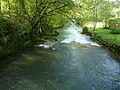
.JPG) The Coly at La Cassagne |
||
| Data | ||
| Water code | FR : P4130500 | |
| location | France , Nouvelle-Aquitaine region | |
| River system | Dordogne | |
| Drain over | Vézère → Dordogne → Atlantic Ocean | |
| source | in the municipality of La Cassagne 45 ° 4 ′ 0 ″ N , 1 ° 17 ′ 32 ″ E |
|
| Source height | approx. 120 m | |
| muzzle | in the local area of Condat-sur-Vézère in the Vézère coordinates: 45 ° 7 ′ 3 ″ N , 1 ° 13 ′ 43 ″ E 45 ° 7 ′ 3 ″ N , 1 ° 13 ′ 43 ″ E |
|
| Mouth height | approx. 79 m | |
| Height difference | approx. 41 m | |
| Bottom slope | approx. 4.1 ‰ | |
| length | 10 km | |
| Catchment area | 169 km² | |
| Left tributaries | Chironde | |
The Coly is a river in France that runs in the Dordogne department in the Nouvelle-Aquitaine region . It rises from a karst spring at La Cassagne and flows into the Vézère at Condat-sur- Vézère .
geography
Doux de Coly
.JPG)
The Coly rises northwest of La Cassagne from the karst spring Doux de Coly , also called Source du Coly or just Dotz in Occitan . It is a bluish shimmering spring pot , about 40 m wide and 10 m deep , directly on Departementsstrasse 62. The dammed spring has an average temperature of 11 ° C and is privately owned. The spring water comes from sinkholes nearby. A dry valley runs above the source . The karst spring pours between 100 and 4000 l / s, the average discharge is 400 l / s.
course
The Coly generally flows in a north-westerly direction, takes up the significantly longer Chironde tributary at Coly and flows into the Vézère as a left tributary after 10 kilometers in the local area of Condat-sur- Vézère .
Places on the river
(Order in flow direction)
- Coly , municipality of Coly-Saint-Amand
- Bouch , Terrasson-Lavilledieu municipality
- Condat-sur-Vézère

Waterfalls of the Coly
The Coly at Bouch

Estuary into the Vézère
.JPG)


Web links
Individual evidence
- ↑ Source geoportail.gouv.fr
- ↑ estuary geoportail.gouv.fr
- ↑ a b c The information on the length of the river is based on the information about the Coly from SANDRE (French), accessed on August 19, 2013, rounded to the nearest kilometer.