East Providence
| East Providence | ||
|---|---|---|
|
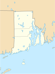
Location in Rhode Island
|
||
| Basic data | ||
| Foundation : | 1862 | |
| State : | United States | |
| State : | Rhode Island | |
| County : | Providence County | |
| Coordinates : | 41 ° 49 ′ N , 71 ° 22 ′ W | |
| Time zone : | Eastern ( UTC − 5 / −4 ) | |
| Residents : | 47,037 (as of 2010) | |
| Population density : | 1,355.5 inhabitants per km 2 | |
| Area : | 43.0 km 2 (approx. 17 mi 2 ) of which 34.7 km 2 (approx. 13 mi 2 ) are land |
|
| Height : | 19 m | |
| Postcodes : | 02914, 02915, 02916 | |
| Area code : | +1 401 | |
| FIPS : | 44-22960 | |
| GNIS ID : | 1219590 | |
| Website : | www.eastprovidenceri.net | |
| Mayor : | Isadore S. Ramos | |
East Providence is the fifth largest city in the state of Rhode Island , United States . It is located in Providence County and is a suburb of Providence . Together with Warwick , Cranston , North Providence and Pawtucket, it belongs to the Providence Metropolitan Area, a metropolitan area with more than 1.5 million inhabitants on the Atlantic coast about 40 km southwest of Boston and 200 km northeast of New York .
geography
The metropolitan area of East Providence is 43 km². almost 20% of it is water, especially that of the Seekonk River . The urban area includes East Providence Center, the villages Watchemoket, Riverside and Rumford. East Providence stretches for several kilometers on the east bank of the Seekonk River and is connected to Providence on the west side of the river via Interstate 195 (a relief route from Interstate 95 ) and the Henderson Expressway.
population
The population was 47,037 at the 2010 census . In 2000, 86.5% of the population were white and 5% were African-Americans . The remaining portion was split between Asians , Hispanics and other ethnic groups. The per capita income was $ 19,527, with about 9% of the population living below the poverty line .
The city has eight public elementary schools, two public middle schools, and three public high schools . There are also several private schools.
history
In the middle of the 17th century, the land of what is now East Providence was acquired by the Indians in several land purchases. The land acquired from the settlers in these land purchases was called Rehoboth . In 1812 most of Rehoboth went to Massachusetts . The settlement area on the east side of the Seekonk River was divided up. The Massachusetts settlement was called Seekonk . The western part, directly on the Seekonk River, was added to Rhode Island in 1862 and called East Providence.
Attractions
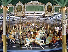
One of East Providence's attractions is the Crescent Park Looff Carousel , a carousel built in 1895 with 100-year-old furnishings. In 1987 it was added to the list of National Historic Landmarks . The list includes several other structures in East Providence, including the Boston and Providence Railroad Bridge , which spans the Ten Mile River , various cemeteries, the Pomham Rocks Light Station - a lighthouse - and various houses, churches, and mills.
sons and daughters of the town
- Arunah Shepherdson Abell (1806-1888), publisher
- Jennifer Lee (* 1971), director, screenwriter and film producer

