
Edde (Hungary)
| Edde | |||||
|
|||||
| Basic data | |||||
|---|---|---|---|---|---|
| State : | Hungary | ||||
| Region : | Southern Transdanubia | ||||
| County : | Somogy | ||||
| Small area until December 31, 2012 : | Kaposvár | ||||
| District since 1.1.2013 : | Kaposvár | ||||
| Coordinates : | 46 ° 32 ' N , 17 ° 43' E | ||||
| Area : | 8.51 km² | ||||
| Residents : | 195 (Jan 1, 2011) | ||||
| Population density : | 23 inhabitants per km² | ||||
| Telephone code : | (+36) 82 | ||||
| Postal code : | 7443 | ||||
| KSH kódja: | 03489 | ||||
| Structure and administration (as of 2020) | |||||
| Community type : | local community | ||||
| Mayoress : | Mariann Nagy (independent) | ||||
| Postal address : | Fő utca 47 7443 Edde |
||||
| Website : | |||||
| (Source: A Magyar Köztársaság helységnévkönyve 2011. január 1st at Központi statisztikai hivatal ) | |||||


Edde is a Hungarian community in the county Kaposvár in Somogy county .
Geographical location
Edde is about 15 kilometers north of the town of Kaposvár . Neighboring communities are Alsóbogát , Osztopán and Somogyjád.
Attractions
- Gáspár Földesi Garden ( Földesi Gáspár kertje )
- Reformed Church, built in 1896
- Festetics Castle ( Festetics-kastély ), built in 1830
- World War Memorial ( I. és II. Világháborús emlékmű )
traffic
Edde can only be reached via a side road that branches off from road no. 6701. The nearest train station is about four kilometers west in Osztopán.
photos

Aerial view of Edde
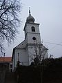
Reformed Church Edde


Individual evidence
- ↑ Öt Èvre kaptak bizalmat a somogyi polgármesterek. Sonline, October 14, 2019, accessed February 29, 2020 (Hungarian).
Web links
Commons : Edde - collection of images, videos and audio files