El Carmen (Pando)
| El Carmen | ||
|---|---|---|
| Basic data | ||
| Residents (state) | 166 pop. (2012 census) | |
| height | 186 m | |
| Post Code | 09-0104-0270-1001 | |
| Telephone code | (+591) | |
| Coordinates | 11 ° 6 ′ S , 67 ° 41 ′ W | |
|
|
||
| politics | ||
| Department | Pando | |
| province | Nicolás Suarez Province | |
| climate | ||
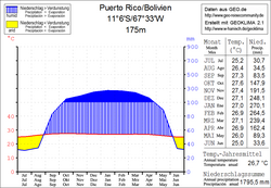
 Climate diagram Puerto Rico |
||
El Carmen is a town in the Pando department in the lowlands of the South American Andean state of Bolivia .
Location in the vicinity
El Carmen is a village in the canton of Costa Rica in the district ( Bolivian : Municipio ) Bella Flor and is located at an altitude of 166 m in the province of Nicolás Suárez . Five kilometers south of El Carmen runs the Río Tahuamanu , the downstream at the city of Puerto Rico with the manuripi river to orthon river combined, the 410 km downstream of the confluence in the Beni River flows.
geography
El Carmen is located in the Bolivian lowlands in the river system of the Amazon , large stretches of the region are still covered with tropical rainforest, the climate of the region is the humid rainy climate of the tropics.
The mean annual temperature of the region is 26.5 ° C (see climate diagram Puerto Rico / Bolivia), the monthly mean temperatures fluctuate only insignificantly between 25 ° C in June and July and over 27 ° C from September to January. The annual precipitation is 1,800 mm, the maximum precipitation is over 200 mm from December to March, and only the short dry season from June to August has monthly precipitation of 30 mm.
Transport network
El Carmen is 154 kilometers by road east of Cobija , the capital of the department.
Of Cobija from 370 kilometers takes highway Ruta 13 east over Porvenir to El Carmen and on to Puerto Rico , where they the orthon river crossing. The end point of Ruta 13 is El Triangulo ( El Choro ), where it meets Ruta 8 , which leads from Guayaramerín and Riberalta in the north to Reyes , Rurrenabaque and Yucumo in the central Bolivian lowlands.
population
The population of the village has increased slightly in the past decade:
| year | Residents | source |
|---|---|---|
| 1992 | no data | census |
| 2001 | 125 | census |
| 2013 | 166 | census |
Individual evidence
- ↑ INE - Instituto Nacional de Estadística Bolivia 1992 ( Memento of the original from April 23, 2014 in the Internet Archive ) Info: The archive link was inserted automatically and has not yet been checked. Please check the original and archive link according to the instructions and then remove this notice.
- ↑ INE - Instituto Nacional de Estadística Bolivia 2001 ( Memento of the original from September 24, 2015 in the Internet Archive ) Info: The archive link has been inserted automatically and has not yet been checked. Please check the original and archive link according to the instructions and then remove this notice.
- ↑ INE - Instituto Nacional de Estadística Bolivia 2012 ( Memento of the original from July 22, 2011 in the Internet Archive ) Info: The archive link has been inserted automatically and has not yet been checked. Please check the original and archive link according to the instructions and then remove this notice.
Web links
- Puerto Rico region - topographic map 1: 100,000 (PDF; 11.30 MB)
- Municipio Bella Flor - General Maps No. 90104
- Municipio Bella Flor - detailed map and population data (PDF; 789 kB) ( Spanish )
- Departamento Pando - social data of the municipalities (PDF; 2.5 MB) ( Spanish )
