Elizabethtown, Illinois
| Elizabethtown | ||
|---|---|---|
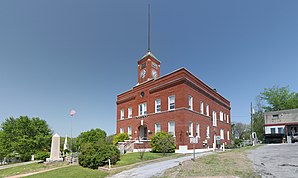
 The Hardin County Courthouse in Elizabethtown |
||
| Location in Illinois | ||
|
|
||
| Basic data | ||
| State : | United States | |
| State : | Illinois | |
| County : | Hardin County | |
| Coordinates : | 37 ° 27 ′ N , 88 ° 18 ′ W | |
| Time zone : | Central ( UTC − 6 / −5 ) | |
| Residents : | 299 (as of 2010) | |
| Population density : | 149.5 inhabitants per km 2 | |
| Area : | 2.0 km 2 (approx. 1 mi 2 ) of which 2.0 km 2 (approx. 1 mi 2 ) are land |
|
| Height : | 111 m | |
| Postal code : | 62931 | |
| Area code : | +1 618 | |
| FIPS : | 17-23191 | |
| GNIS ID : | 407872 | |
Elizabethtown is a village and the administrative seat of Hardin County in the south of the US -amerikanischen state of Illinois . At the 2010 census , Elizabethtown had 299 residents.
geography
Elizabethtown is 37 ° 26'57 "north latitude and 88 ° 18'13" west longitude and extends over 2.0 km², which consists exclusively of land. The place is on the north bank of the Ohio River , which forms the border with Kentucky .
The location is in the west, north and east of the Shawnee National Forest surrounded, a 1,100 square kilometer National Forest , which covers several counties in Southern Illinois.
There is a ferry connection from Elizabethtown over the Ohio to Kentucky.
The closest places are Rosiclare (7.4 km southwest) and Cave-In-Rock (17.3 km east), which also has a ferry service across the Ohio to Kentucky.
The closest major cities are Louisville , Kentucky (337 km east-northeast), Nashville , Tennessee (232 km southeast), Memphis , Tennessee (395 km southwest), St. Louis , Missouri (261 km northwest), and Indianapolis , Indiana (408 km northeast) .
Elizabethtown is the southern end point of Illinois State Route 34 , which meets a few kilometers east of the town on Illinois State Route 146 , which runs in a west-east direction .
Demographic data
In the official census in 2000 , the population was 348. These were distributed over 183 households in 99 families. The population density was 191.9 inhabitants per square kilometer. There were 226 residential buildings, which corresponded to a building density of 191.9 buildings per square kilometer.
The population in 2000 was 98.0 percent white and 1.4 percent African American . 0.6 percent said they came from at least two of these groups. 0.29 percent of the population were Hispanics from any of the above groups.
17.0 percent were under 18 years of age, 8.3 percent between 18 and 24, 15.5 percent between 25 and 44, 30.2 percent between 45 and 64 and 29.0 percent 65 and older. The mean age was 51 years. Statistically, there were 87.1 men for every 100 women, 81.8 among those over 18.
The median income per household was 17,750 US dollars (USD), the median family income 38,750 USD. The median income for men was $ 30,625 and that for women was $ 16,563. The per capita income was $ 17,567. Around 16.0 percent of families and 22.5 percent of the total population had their income below the poverty line .
Individual evidence
- ^ US Census 2010.Retrieved December 14, 2011
- ↑ Google Maps: Shawnee National Forest.Retrieved December 14, 2011
- ↑ Google Maps: Elisabethtown, IL - Rosiclare, IL Retrieved December 14, 2011
- ↑ Google Maps: Elizabethtown, IL - Cave-In-Rock, IL. Retrieved December 14, 2011
- ↑ Google Maps: Elisabethtown, IL - Louisville, KY.Retrieved December 14, 2011
- ↑ Google Maps: Elizabethtown, IL - Nashville, TN.Retrieved December 14, 2011
- ↑ Google Maps: Elizabethtown, IL - Memphis, TN.Retrieved December 14, 2011
- ↑ Google Maps: Elizabethtown, IL - St. Louis, MO. Retrieved December 14, 2011
- ↑ Google Maps: Elizabethtown, IL - Indianapolis, IN.Retrieved December 14, 2011
- ^ US Census Bureau - Elizabethtown, IL Retrieved December 14, 2011
