Narrow peninsula
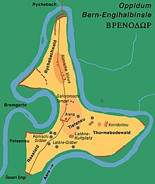
The narrow peninsula is the peninsula-like , z. Partly inhabited area within a bend in the river Aare in the north of the city of Bern .
geography
Place and field names in the region are Zehendermätteli (Zehndermätteli), Thormemätteli , Senftau , Tiefenau , Felsenau , Aaregg and Rossfeld . Zehendermätteli, a forest clearing with a nursery and a restaurant, is located in the west of the Engeh peninsula. In the north is the Rychebachwald and in the east the Thormebodewald . Both are largely closed forest areas with only small paths around which the Aare flows.
History of construction and settlement
The area was already settled during the Latène period (5th – 1st century BC). The oldest documented settlement was probably one since the second half of the 2nd century BC. Large Celtic settlement fortified on the narrow peninsula. She must have been one of the twelve Oppida of Helvetii mentioned by Julius Caesar .
From the Gallo-Roman era, in which u. a. is understood as a Roman city quarter ( Vicus ), were u. a. excavated a small amphitheater and thermal bath . An important find from the Helvetic settlement is the Bern zinc plate .
The walls of the amphitheater, measuring 27.55 by 25.30 meters, were discovered in 1880 and initially interpreted as a water reservoir. Immediately next to it was a powder tower built in 1738 and since 1763 surrounded by a high sandstone wall. Only when it had to give way to the construction of the Matthäuskirche ( tetrahedron shape, stepped angular tower, parish hall Rossfeld ) at Reichenbachstrasse 114 in 1955 did the original function of the Roman masonry become recognizable.
Development
Today's residential and recreational area is accessed by long-distance traffic through Tiefenaustrasse (No.12) or accessed from the southwest and exited from it in the northeast via a bridge over the Aare. The A1 runs not far, but on the other side of the Aare, in the south and east. The A6 meets the A1 in the southeast.
The Aare can be crossed to the west with the Zehendermätteli – Bremgarten ferry and you get to the Bremgarten community .
The Reichenbach – Engeh peninsula ferry in the north connects the Engeh peninsula with the area of Reichenbach Castle in the municipality of Zollikofen . At the site of the castle there was most likely a river fort in Roman times, which was connected to the castrum on the narrow peninsula.
See also
Web links
- Archaeological tour
- Information on the narrow peninsula from the Archaeological Service of the Canton of Bern
Individual evidence
- ^ Anne-Marie Dubler , Hans Grütter: Bern (municipality) - 1.1 Pre-Roman times. In: Historical Lexicon of Switzerland . November 10, 2016 , accessed July 8, 2019 .
Coordinates: 46 ° 59 ' N , 7 ° 27' E ; CH1903: 601119 / 202,659


