Erlenbach (Thaler Bach)
| Erlenbach | ||
|
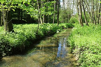
Erlenbach in the breakthrough between Madersberg and Kirchberg |
||
| Data | ||
| location | Styria , Austria | |
| River system | Danube | |
| Drain over | Thaler Bach → Mühlgang → Mur → Drau → Danube → Black Sea | |
| source | east of Straßengelberg 47 ° 5 ′ 50 ″ N , 15 ° 20 ′ 36 ″ E |
|
| Source height | 676 m above sea level A. | |
| muzzle | in the Thaler Graben in the Thaler Bach Coordinates: 47 ° 4 ′ 45 " N , 15 ° 21 ′ 55" E 47 ° 4 ′ 45 " N , 15 ° 21 ′ 55" E |
|
| Mouth height | 425 m above sea level A. | |
| Height difference | 251 m | |
| Bottom slope | 71 ‰ | |
| length | 3.5 km | |
| Catchment area | 3.77 km² | |
| Communities | Thal | |
The Erlenbach is a left bank tributary of the Thaler Bach in the Austrian state of Styria . It drains the central settlement area in the Thaler Basin near the provincial capital Graz .
course
The Erlenbach rises in the forest east of the Straßengelberg in the north of the municipality of Thal. It initially runs as a periodic channel through a ditch running in a south-south-east direction and separates the two hamlets Schlüsselhof and Kötschberg from each other. After crossing agricultural areas, the stream reaches a flood retention basin . In Unterthal he takes the right two smaller feeder and is distracted from Thaler Kirchberg in northeast. After an orthogonal bend near Unterbichl , the Erlenbach breaks through the limestone clod of the Graz Paleozoic Era and separates the Madersberg in the north from the Kirchberg in the south, before it flows into the creek of the same name on the L339 (Thalerseestraße) in the Thaler Graben .
Flood protection
Due to recurring flooding in Thal and Graz-Gösting by the Thaler Bach and its largest feeder Erlenbach, a flood protection project was started in 2011. After two years of construction, a retention basin was in June 2018 east of Castle Oberthal completed that long m over a 250 m high and 4.3 Homogeneous dam with a cubic volume has m³ of about 8000th This should make it possible to reduce the discharge in the event of a 100- year flood (HQ 100 ) with a storage capacity of almost 32,000 m³ from 12.4 to 1.2 m³ / s. Because the subsoil was only partially stable, a pre- load had to be applied before the dam and the bottom outlet were built and the settlement had to be awaited.
In the district of Unterthal, a linear expansion of the stream was carried out in the same period on a 700 m long stretch of river. For this one was Krainer wall of larch built and improved with a widening of the stream profile, the ecological situation. The total costs for the protective measures amounted to 1.75 million euros and were borne by the federal government, the state and the municipality as well as the city of Graz.
Web links
Individual evidence
- ↑ Digital Atlas of Styria: Waters & Water Information. State of Styria , accessed on May 6, 2020 .
- ↑ Extract from the digital Steiermark (Erlenbach) water index. State of Styria , accessed on May 6, 2020 .
- ↑ BMLFUW (ed.) : List of areas of the Austrian river basins: Mur area. In: Contributions to Austria's Hydrography Issue No. 60, Vienna 2011, p. 77. PDF download , accessed on May 6, 2020.
- ↑ a b Erlenbach: Completion of the flood protection. State of Styria , June 2018, accessed on May 6, 2020 .
- ↑ a b The risk of flooding subdued. New Land, June 19, 2018, accessed May 6, 2020 .

