Esmeralda (Oruro)
| Esmeralda | ||
|---|---|---|
 Esmeralda in the plain of the Río Lauca |
||
| Basic data | ||
| Full name | Amanzanada Esmeralda | |
| Residents (state) | 231 pop. (2012 census) | |
| height | 3747 m | |
| Post Code | 04-0505-0100-1005 | |
| Telephone code | (+591) | |
| Coordinates | 18 ° 51 ′ S , 68 ° 17 ′ W | |
|
|
||
| politics | ||
| Department | Oruro | |
| province | Litoral Province | |
| climate | ||
 Climate diagram Sabaya |
||
Esmeralda (also: Amanzanada Esmeralda ) is a town in the Oruro department in the highlands of the South American Andean state of Bolivia .
Location in the vicinity
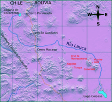
Esmeralda is the central place of the district ( Bolivian : Municipio ) Esmeralda in the province of Litoral and is located on the Bolivian Altiplano . Esmeralda is located at an altitude of 3747 m on the western slope of a mountain range made up of two Quaternary stratovolcanoes , the Pacha Kkollu Quimsa Misa (4702 m) in the northwest and the Inca Camacho (4792 m) in the east.
geography
The climate is semi-arid and has a short rainy season in summer, the annual precipitation is low 200 mm (see climate diagram Sabaya). The annual average temperature is almost 7 ° C without significant fluctuations in the course of the year, but with strong daily fluctuations in temperature and frequent changes in frost .
The vegetation in the Esmeralda area corresponds to the semi-arid puna . It is treeless and mainly consists of thorn bushes , grasses , succulents and cushion plants . It is used economically as a llama , alpaca and sheep pasture .
Transport network
Esmeralda is 168 kilometers by road south-west of Oruro , the capital of the department.
From Oruro the dirt road Ruta 12 leads via Toledo , Ancaravi and Huachacalla to Esmeralda . The road continues via Sabaya to Pisiga on the Chilean border and to Colchane in Chile .
population
The population of the village has doubled in the past decade:
| year | Residents | source |
|---|---|---|
| 1992 | . | no data |
| 2001 | 119 | census |
| 2012 | 231 | census |
Due to the historical population distribution, the region has a high proportion of indigenous population, in the municipality of Esmeralda 81.6 percent of the over 6-year-olds speak the Aymara language .
Individual evidence
- ^ INE - Instituto Nacional de Estadística Bolivia 2001 ( Memento of February 23, 2014 in the Internet Archive )
- ^ INE - Instituto Nacional de Estadística Bolivia 2012 ( Memento of July 22, 2011 in the Internet Archive )
Web links
- Relief map of the Nevado Sajama region 1: 250,000 (PDF; 11.0 MB)
- Municipio Esmeralda - General Maps No. 40505
- Municipio Esmeralda - detailed map and population data (PDF; 309 kB) ( Spanish )
- Departamento Oruro - Social data of the municipalities (PDF; 5.86 MB) ( Spanish )
