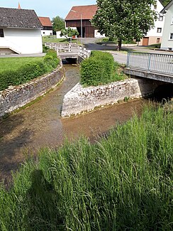
Esselbergbach
|
Esselbergbach Mühlbach |
||
|
It flows into the Morsbach |
||
| Data | ||
| location |
Southern Franconian Alb
|
|
| River system | Danube | |
| Drain over | Morsbach → Anlauter → Schwarzach → Altmühl → Danube → Black Sea | |
| origin | approx. 0.5 km northeast of Morsbach 49 ° 1 ′ 40 ″ N , 11 ° 15 ′ 52 ″ E |
|
| Source height | approx. 476 m above sea level NN | |
| muzzle | through Morsbach from the left and northeast into the Morsbach coordinates: 49 ° 1 ′ 15 ″ N , 11 ° 15 ′ 21 ″ E 49 ° 1 ′ 15 ″ N , 11 ° 15 ′ 21 ″ E |
|
| Mouth height | 458 m | |
| Height difference | approx. 18 m | |
| Bottom slope | approx. 14 ‰ | |
| length | 1.3 km | |
The Esselbergbach , locally Mühlbach, is a 1.3 km long brook of the Franconian Alb in the area of the market town of Titting in the Upper Bavarian district of Eichstätt .
geography
course
The Esselbergbach arises at about 476 m above sea level. NHN approx. 0.9 km northwest of Morsbach , which can be traced a few kilometers further uphill as a dry valley. The brook initially flows southwest towards Morsbach and passes a pond on the left bank and flows past the Hainmühle. In the past she used the water of the Esselbergbach to grind the grain. In Morsbach it then flows from the left to about 458 m above sea level. NHN of the same length as Morsbach .
The Esselbergbach flows after a 1.3 km long run with an average bed gradient of around 14 ‰, about 18 meters below its origin.
Catchment area
The brook drains an area of 30.8 km², which naturally belongs to the sub-area Anlauteralb of the Southern Franconian Alb.
The watercourses and most of the catchment area are located in the area of the market town of Titting and in the east the town of Greding , which belongs to the Central Franconian district of Roth , has large shares in it.
Web links
Individual evidence
- ↑ a b Height according to the contour diagram on the BayernAtlas
- ↑ Directory of the brook and river areas in Bavaria - Lech to Naab river area, page 120 of the Bavarian State Office for the Environment, as of 2016 (PDF; 2.9 MB) (currently on page 120)
- ^ Esselbergbach, Upper Bavaria, Bavaria, Germany. Retrieved May 13, 2018 .
- ^ Franz Tichy : Geographical Land Survey: The natural spatial units on sheet 163 Nuremberg. Federal Institute for Regional Studies, Bad Godesberg 1973. → Online map (PDF; 4.0 MB)
- ↑ Ralph Jätzold: Geographical land survey: The natural space units on sheet 172 Nördlingen. Federal Institute for Regional Studies, Bad Godesberg 1962. → Online map (PDF; 3.9 MB)
