
Ferchenbach
| Ferchenbach | ||
 Surroundings of the Ferchenbach |
||
| Data | ||
| Water code | DE : 16242 | |
| location | District of Garmisch-Partenkirchen , Upper Bavaria , Bavaria , Germany | |
| River system | Danube | |
| Drain over | Partnach → Loisach → Isar → Danube → Black Sea | |
| origin |
Ferchensee 47 ° 25 ′ 38 ″ N , 10 ° 59 ′ 56 ″ E |
|
| Source height | 1060 m above sea level NN | |
| muzzle | in the Partnach coordinates: 47 ° 26 '25 " N , 11 ° 12' 39" E 47 ° 26 '25 " N , 11 ° 12' 39" E |
|
| Mouth height | 796 m | |
| Height difference | 264 m | |
| Bottom slope | 25 ‰ | |
| length | 10.5 km | |
| Communities | Mittenwald , Krün , Garmisch-Partenkirchen | |
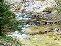
 Ferchenbach shortly before the confluence with the Partnach. |
||
The Ferchenbach is the outflow of the Ferchensee , which in turn is fed by several small streams. The Ferchenbach flows first between Kranzberg and Wettersteinwand to the northwest and then turns off at the level of Elmau and flows south of the Wambergsattels to the west. It flows into the Partnach approx. 250 m before it enters the Partnach Gorge .
Several mountain streams flow into the Ferchenbach, including the Drüsselgraben (from the right) and the Elmauer Bach (from the left).
More photos

Outflow of the Ferchenbach from the Ferchensee.
Ferchenbach between Ferchensee and Elmau.

Ferchenbach west of Elmau.

Exit of the Ferchenbach valley at Hintergraseck. In the background the Alpspitze.

The Ferchenbach flows into the Partnach (from the right).


