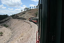
Ferrocarril Chihuahua al Pacífico
The Ferrocarril Chihuahua al Pacífico (abbreviated ChP, therefore often called Chepe ) is a railway line and a former railway company in Mexico . The line is single-track, not electrified and is considered to be one of the most spectacular railway lines in the world.
It was built between 1861 and 1961 for freight traffic to transport corn, grain and copper to the ports. Operators were initially the Kansas City, Mexico and Orient Railway on the section from Topolobampo to San Pedro en Sinaloa and the Ferrocarril Noroeste , the route coming from the east ended in Creel . The topographically difficult section between San Pedro and Creel was not completed until 1961. At this time, the two railway companies, nationalized in 1940, merged to form the Ferrocarril Chihuahua al Pacífico and began traveling. The route has been part of the network of the private operator Ferromex since 1998. In addition to the freight trains, it is served by the only regular passenger train in Mexico ("El Chepe"), which runs from Los Mochis in the state of Sinaloa to Chihuahua and back.
From the port town of Topolobampo on the Pacific coast , the route leads via Los Mochis to El Fuerte and then meanders through the rugged rocks of the Sierra Madre Occidental , past vertiginous deep gorges and bizarre rock formations. A height difference of 2400 m is overcome over many bridges and through numerous tunnels. During the journey, which lasts several hours, the train travels through various forms of landscape and vegetation: the Pacific coast with its subtropical climate as well as cool mountain regions and cactus steppes.
Technical
| Ojinaga – Chihuahua – Pacific | |||||||||||||||||||||||||||||||||||||||||||||||||||||||||||||||||||||||||||||||||||||||||||||||||||||||||||||||||||||||||||||||||||||||||||||||||||||||||||||||||||||||||||||||||||||||||||||||||
|---|---|---|---|---|---|---|---|---|---|---|---|---|---|---|---|---|---|---|---|---|---|---|---|---|---|---|---|---|---|---|---|---|---|---|---|---|---|---|---|---|---|---|---|---|---|---|---|---|---|---|---|---|---|---|---|---|---|---|---|---|---|---|---|---|---|---|---|---|---|---|---|---|---|---|---|---|---|---|---|---|---|---|---|---|---|---|---|---|---|---|---|---|---|---|---|---|---|---|---|---|---|---|---|---|---|---|---|---|---|---|---|---|---|---|---|---|---|---|---|---|---|---|---|---|---|---|---|---|---|---|---|---|---|---|---|---|---|---|---|---|---|---|---|---|---|---|---|---|---|---|---|---|---|---|---|---|---|---|---|---|---|---|---|---|---|---|---|---|---|---|---|---|---|---|---|---|---|---|---|---|---|---|---|---|---|---|---|---|---|---|---|---|---|
| Course book range : | Q | ||||||||||||||||||||||||||||||||||||||||||||||||||||||||||||||||||||||||||||||||||||||||||||||||||||||||||||||||||||||||||||||||||||||||||||||||||||||||||||||||||||||||||||||||||||||||||||||||
| Route length: | 941.3 km | ||||||||||||||||||||||||||||||||||||||||||||||||||||||||||||||||||||||||||||||||||||||||||||||||||||||||||||||||||||||||||||||||||||||||||||||||||||||||||||||||||||||||||||||||||||||||||||||||
| Gauge : | 1435 mm ( standard gauge ) | ||||||||||||||||||||||||||||||||||||||||||||||||||||||||||||||||||||||||||||||||||||||||||||||||||||||||||||||||||||||||||||||||||||||||||||||||||||||||||||||||||||||||||||||||||||||||||||||||
|
|||||||||||||||||||||||||||||||||||||||||||||||||||||||||||||||||||||||||||||||||||||||||||||||||||||||||||||||||||||||||||||||||||||||||||||||||||||||||||||||||||||||||||||||||||||||||||||||||
The Ferrocarril Chihuahua al Pacífico operates on the southern section of the Mexican route Q.
Between Bahuichivo and Temoris , the route has 37 bridges with a total length of 3.6 km, of which the Puente Fuerte is the longest at 498.8 m. The 87 tunnels are more than 17 km long. Gradients, bends and spiral loops built into the mountain lead higher and higher, until finally at Los Ojitos , between the Divisadero and Creel stations , at 2,420 m, the highest point of the 653 km long route is reached. From there it goes back down in stages towards Chihuahua.
Among the attractions on the route is El Descanso, the longest tunnel on the route at over 1,800 m. At kilometer 622 ( measured from Ojinaga , the eastern border point with the United States ), the train reaches Divisadero station, the topographical highlight of the route. From there, as well as from Creel afterwards, one has a view of the 1759 m deep Barranca del Cobre (Copper Gorge).
Web links
- Official website (Spanish; with English version )
- Train journey through Mexico: "Anyone who drives a car here is stupid" , article by Sonja Peteranderl in Spiegel Online , May 23, 2013
Individual evidence
- ^ In the Schluchten-Zug in: Nordbayerischer Kurier of December 31, 2016, p. 43
- ↑ Ferrocarril Chihuahua al Pacífico: Maps: Route height ( Memento of the original from May 7, 2013 in the Internet Archive ) Info: The archive link was inserted automatically and has not yet been checked. Please check the original and archive link according to the instructions and then remove this notice.
- ↑ Bridge damaged by fire in 2008, reopening planned for 2019. https://www.rtands.com/track-structure/bridge-retaining-walls-tunnels/groundbreaking-ceremony-held-for-presidio-international-rail-bridge/


