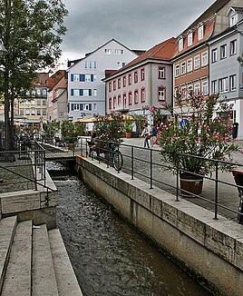
Flappach
| Flappach | ||
| Data | ||
| Water code | DE : 215474 | |
| location |
Lake Constance young moraine land
|
|
| River system | Rhine | |
| Drain over | Shoten → Rhine → North Sea | |
| source | near Ravensburg- Kemmerlang 47 ° 44 ′ 18 ″ N , 9 ° 37 ′ 41 ″ E |
|
| Source height | 545 m above sea level NHN | |
| muzzle | in Ravensburg from the left and south-east in the middle Schussen coordinates: 47 ° 46 '55 " N , 9 ° 36' 5" E 47 ° 46 '55 " N , 9 ° 36' 5" E |
|
| Mouth height | 430 m above sea level NHN | |
| Height difference | 115 m | |
| Bottom slope | 17 ‰ | |
| length | 6.9 km | |
| Catchment area | 9.066 km² | |
| Flowing lakes | Flappachweiher | |
The Flappach , sometimes also called Flattbach or Stadtbach , is an approximately 7 km long, left and southeastern tributary of the Schussen, which flows into Lake Constance, in Ravensburg in the Ravensburg district in southern Upper Swabia in Baden-Württemberg .
course
The Flappach rises from the Flappach springs near Kemmerlang . Shortly afterwards it flows through the Flappachweiher and from there on through Ittenbeuren past Knollengraben through the Flappach Valley into the Mühlenvorstadt of Ravensburg . There it flows as a city stream, partially exposed, through the city center. It flows into the Schussen at the former Pfannenstiel tannery and dyeing district .
Flappachweiher
The Flappachweiher , originally created as an artificial reservoir, is now an idyllic natural outdoor pool. The pond with a water surface of 5.7 hectares is fed by an inlet in the south and by the Flappach springs in the hillside forest in the east.
Mills
In the 19th century, the Flappach drove six paper mills , eight grinding mills , three sawmills , three oil mills , five fulling mills , a Lohrstampf , a spinning mill and an iron hammer . Today the Mönchmühle Ravensburg is the last still intact mill on the Flappach. The Mönchmühle Ravensburg is part of the Mühlenstraße Oberschwaben .
Ravensburg water board
On September 29, 1843, 20 engine owners founded the Ravensburg waterworks company on the Flappach in order to create a reservoir. The reservoir should not be used for swimming or fishing purposes, but for an even water supply to the engines. For this purpose, the company acquired land on the Kemmerlanger Moos between 1843 and 1846 and had the reservoir built. Between 1903 and 1904 the stone pond was built in Ittenbeuren. The former waterworks company is now called Wasserverband Ravensburg and is still the owner of the two reservoirs.
Landscape protection area
The Flappach water system is located in the FFH area Schussen and Schmalegger Tobel with the area number DE8323341, which is also a Natura 2000 area. As far as the Flappachweiher, the Flappach flows through the Flattbach landscape protection area (LfU number LSG 4.36.058) and the Kemmerlanger Moos nature reserve (NSG 4.139). The springs are protected by the water protection areas Flappachquellen (WSG 436072) and Mostbrunnen (WSG 436114). After the Flappachweiher, the Flappach flows past the extensive natural monument Streuwiesen am Flappach (protected area no .: FND084360640224).
Web links
- Flappachbad city of Ravensburg
- Map of LSG Flattbach (LUBW State Institute for Environment, Measurements and Nature Conservation Baden-Württemberg)
swell
- ^ Hansjörg Dongus : Geographical land survey: The natural spatial units on sheet 187/193 Lindau / Oberstdorf. Federal Institute for Regional Studies, Bad Godesberg 1991. → Online map (PDF; 6.1 MB)
- ↑ a b State Institute for the Environment Baden-Württemberg (LUBW) ( information )
- ↑ Seeportrait Flappachweiher on www.seenprogramm.de ( Memento from May 17, 2008 in the Internet Archive ) (Pro Regio Oberschwaben)
- ↑ Friedrich Gutermann: The oldest history of the fabrication of the linen paper. 1845, note 35. (on Wikisource)
- ↑ LSG Flattbach
- ^ NSG Kemmerlanger Moos
- ^ Information from the Baden-Württemberg Ministry of the Environment on the water protection areas BG Alpenrhein-Bodensee
- ↑ FND Streuwiesen am Flappach
