Flinsberg (Heilbad Heiligenstadt)
|
Flinsberg
City of Heilbad Heiligenstadt
Coordinates: 51 ° 19 ′ 2 " N , 10 ° 11 ′ 28" E
|
|
|---|---|
| Height : | 451 m above sea level NN |
| Residents : | 160 |
| Incorporation : | June 15, 1991 |
| Postal code : | 37308 |
| Area code : | 036084 |
|
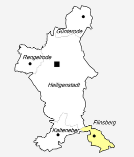
Location of Flinsberg in Heilbad Heiligenstadt
|
|
|
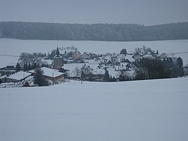
Flinsberg seen from the west in winter
|
|
Flinsberg is a rural district of the city of Heilbad Heiligenstadt in the Eichsfeld district in Thuringia .
location
Flinsberg is about 7 kilometers southeast of the spa in a convenient location. There the state roads 1006, 1007 and 2045 run through the district. Western neighboring is also predominantly agricultural district Kalteneber , located in the northeast Heuthen , southeast Wachstedt and southern Martin Field .
Flinsberg is located on the Obereichsfelder Höhe , immediately south of the waiting mountain (515.9 m). When calculating according to the minimum distance to the national border, the center of Germany is in the district of Finsberg below the mountain top Auf der Kapelle (480.4 m). The Rosoppe , a tributary of the Frieda, rises in the village .
history
The village was first mentioned in 1268 as Flinßberg . The Middle High German vlins means something like stone chips or pebbles. On June 15, 1991 Flinsberg became a district of Heiligenstadt. Around 160 people live here today.
Worth seeing
- the small church "St. Martin" from 1758
- Monument at the geographical center
- wide view from waiting mountain to Brocken in the north and Inselsberg in the south
Individual evidence
- ↑ Erhard Müller: The place names of the district of Heiligenstadt. Heilbad Heiligenstadt 1989, p. 16


