
Foglia
| Foglia | ||
 The Foglia near Pesaro |
||
| Data | ||
| location | Marche , Italy | |
| River system | Foglia | |
| River basin district | Appennino Centrale | |
| source | in the province of Arezzo in Tuscany, near the Sasso Aguzzo 43 ° 41 ′ 43 ″ N , 12 ° 14 ′ 37 ″ E |
|
| muzzle | in Pesaro in the Adriatic Coordinates: 43 ° 55 ′ 25 ″ N , 12 ° 54 ′ 5 ″ E 43 ° 55 ′ 25 ″ N , 12 ° 54 ′ 5 ″ E
|
|
| length | 90 km | |
| Medium-sized cities | Pesaro | |
| Communities | Sestino , Belforte all'Isauro , Piandimeleto , Sassocorvaro , Auditore , Montecalvo in Foglia , Montelabbate | |
The Foglia is the northernmost river in the Marche region of Italy, which spends its first 9 km in Tuscany . Its total length is 90 km.
course
The river has its source in the province of Arezzo in Tuscany, near the Sasso Aguzzo , a hill near the municipalities of Sestino and Badia Tedalda in the Tuscan Apennines . It then flows through the municipalities of Sestino (AR) , Belforte all'Isauro (PU) , Piandimeleto (PU), Lunano (PU), Sassocorvaro (PU), Auditore (PU), Montecalvo in Foglia (PU), Montelabbate (PU) and Pesaro (PU), from where it flows into the Adriatic Sea.
history
In the time of the Picenians (up to the 3rd century BC ) the Foglia was the northern border of their empire. It also served the Vicariate of Urbino as an eastern border.
Origin of name
The river's Latin name was Pisaurum , named after the Roman name for the city of Pesaro in the province of Pesaro and Urbino , which it crosses as the last major commercial center.
photos

The Foglia shortly after its formation near Sestino at the confluence with the Bornacchio
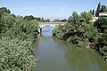
The Foglia near Pesaro just before it flows into the Adriatic Sea

