
Badia Tedalda
| Badia Tedalda | ||
|---|---|---|

|
|
|
| Country | Italy | |
| region | Tuscany | |
| province | Arezzo (AR) | |
| Coordinates | 43 ° 42 ' N , 12 ° 11' E | |
| height | 700 m slm | |
| surface | 119 km² | |
| Residents | 1,030 (Dec. 31, 2019) | |
| Population density | 9 inhabitants / km² | |
| Post Code | 52032 | |
| prefix | 0575 | |
| ISTAT number | 051003 | |
| Popular name | Badiali | |
| Patron saint |
San Michele Arcangelo (September 29th) |
|
| Website | Badia Tedalda | |
 Badia Tedalda (Alta), Via Castello |
||

Badia Tedalda is an Italian commune with 1030 inhabitants (as of December 31, 2019) in the province of Arezzo in the Tuscany region .
geography
.svg)
The municipality is located about 35 km northeast of the provincial capital Arezzo and 80 km east of the regional capital Florence in the Marecchia valley (Valmarecchia) and on the Marecchia river . It lies in the climatic classification of Italian communities in Zone E, 2 713 GG. The Passo di Viamaggio is located in the western municipality .
The main town is divided into the ancient and higher part of Tedalda Alta , where the abbey was located and where the Chiesa di San Michele Arcangelo still stands today. The town hall is located in the Tedalda Bassa part below Alta .
The districts include Caprile (815 meters above sea level), Castellacciola , Fresciano-Montebotolino , Montelabreve , Pratieghi (857 m, approx. 110 inhabitants), Rofelle (708 m), Sant'Andrea , Stiavola and Viamaggio (891 m).
The municipal area also includes the Ca 'Raffaello exclave (418 meters above sea level, approx. 280 inhabitants, 8 km north), with the three localities Cicognaia (630 m), Monterotondo (no district) and Santa Sofia Marecchia (600 m, 9 km north), which is separated from the main territory by the province of Rimini . The towns became part of the municipality in 1607 when the Grand Duke of Tuscany, Ferdinando I de 'Medici , bought territories in what was then Marche ( Province of Pesaro and Urbino , since 2009 Province of Rimini, Emilia-Romagna ).
The neighboring municipalities are Borgo Pace ( PU ), Casteldelci ( RN ), Pennabilli (RN), Pieve Santo Stefano , Sansepolcro , Sant'Agata Feltria (RN), Sestino and Verghereto (FC) .
history
The municipality was probably created by the Romans who settled on the Via Ariminensis between Arezzo and Rimini . In the Middle Ages the two were in abbeys of Benedictines , the present di Arduino and the dei Tedaldi who in 1205 with the expansion of the church Chiesa di San Michele Arcangelo were merged. In 1489 the place came under the influence of Florence . Today's village was on 24 July 1775 by decree of Grand Duke Leopold I founded. After the unification of Italy in 1861, around 2350 people lived in the municipality. This number increased to around 3700 until the 1920s. After that, the population decreased steadily, so that in 2010 only 1118 people lived in the village.
Attractions
- Chiesa di San Michele Arcangelo , built in the 10th century and expanded in 1205 in Tedalda Alta, the interior was renovated in 1520 on the initiative of Leonardo Buonafede. Contains by Benedetto Buglioni the work Madonna e quattro Santi ( terracotta figure from 1516) and by Santi Buglioni the work I santissimi Giuliano, Sebastiano e Antonio, completed in 1522 .
- Chiesa della Madonna del Presale , church on the banks of the Marecchia river, documented as early as the 12th century.
- Chiesa di Santa Maria a Rofelle , church built in the 12th century in the Rofelle district.
- Chiesa di San Tommaso a Montebotolino , church in the district of Montebotolino from the 13th century.
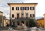
Town Hall and Piazza dei Tedaldi in Tedalda Bassa

Chiesa di San Michele Arcangelo
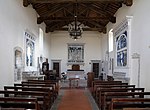
Interior of the Church of S. Michele Arcangelo
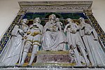
Terracotta Madonna e quattro Santi

Terracotta I santissimi Giuliano, Sebastiano e Antonio

Chiesa di Santi Pietro e Paolo in the Fresciano district

Terracotta by Santi Buglioni in Fresciano


literature
- Emanuele Repetti: Dizionario Geografico Fisico Storico della Toscana ; Online edition of the University of Siena on Badia Tedalda
- Touring Club Italiano : Toscana , p. 820, Milan 2003, ISBN 978-88-365-2767-0
Web links
Individual evidence
- ↑ Statistiche demografiche ISTAT. Monthly population statistics of the Istituto Nazionale di Statistica , as of December 31 of 2019.
- ↑ Toscana.it website for the Chiesa di San Tommaso a Montebotolino

Anghiari | Arezzo | Badia Tedalda | Bibbiena | Bucine | Capolona | Caprese Michelangelo | Castel Focognano | Castel San Niccolò | Castelfranco Piandiscò | Castiglion Fibocchi | Castiglion Fiorentino | Cavriglia | Chitignano | Chiusi della Verna | Civitella in Val di Chiana | Cortona | Foiano della Chiana | Laterina Pergine Valdarno | Loro Ciuffenna | Lucignano | Marciano della Chiana | Monte San Savino | Montemignaio | Monterchi | Montevarchi | Ortignano Raggiolo | Pieve Santo Stefano | Poppi | Pratovecchio Stia | San Giovanni Valdarno | Sansepolcro | Sestino | Subbiano | Talla | Terranuova Bracciolini