Fonollosa
| Fonollosa municipality | ||
|---|---|---|
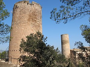
 Fonollosa - Castell de Fals
|
||
| coat of arms | Map of Spain | |

|
|
|
| Basic data | ||
| Autonomous Community : |
|
|
| Province : | Barcelona | |
| Comarca : | Bages | |
| Coordinates | 41 ° 47 ' N , 1 ° 42' E | |
| Height : | 525 msnm | |
| Area : | 52.15 km² | |
| Residents : | 1,453 (Jan 1, 2019) | |
| Population density : | 27.86 inhabitants / km² | |
| Postal code : | 08259 | |
| Municipality number ( INE ): | 08084 | |
| administration | ||
| Website : | www.marganell.net | |
Fonollosa is a place and a municipality ( municipi ) with 1453 inhabitants (as of January 1, 2019) in the comarca of Bages in the province of Barcelona in the autonomous region of Catalonia . The localities of Camps, Canet de Fals and Fals also belong to the municipality .
location
The place Fonollosa is at an altitude of about 300 meters above sea level. d. M. on the edge of Montserrat in the cultural and wine landscape Pla de Bages . The cities of Manresa and Barcelona are about 18 kilometers and 90 kilometers (driving distance) to the southeast.
Population development
| year | 1960 | 1970 | 1981 | 1990 | 2000 | 2010 |
| Residents | 816 | 656 | 628 | 677 | 1,018 | 1,401 |
Despite the phylloxera crisis in viticulture and the increasing mechanization of agriculture , the population of the municipality has remained more or less constant since the middle of the 19th century.
economy
In the past, the inhabitants lived mainly as a self-sufficiency from agriculture , which also included growing wine and keeping livestock (especially sheep and goats ). As early as the end of the Middle Ages , Fonollosa and Fals also functioned as craft and mercantile centers for the villages and individual farms ( masies ) in the area. Since the 1960s tourism has also played a not insignificant role in the municipality's income.
history
The Dolmen de Betlem dates from the Neolithic ; ancient , Visigoth and Islamic traces have not yet been discovered. In the 9th and 10th centuries, the almost deserted region was recaptured ( reconquista ) from the hands of Islam by the Counts of Barcelona , repopulated ( repoblación ) and secured with castles ( castells ) and churches ( esglésies or ermitas ).
Attractions
- Fals
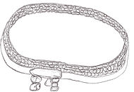
- The Dolmen de Betlem , discovered near Fals after a forest fire in 1994, is a testimony to the time of the megalithic cultures ; he is thus in the 4th or 3rd millennium BC. To date. A curtain wall made of stacked field stones was discovered in its immediate vicinity. It is unclear whether the two buildings belong together or were erected at different times.
- The two Torres de Fals belonged to a medieval castle , which, however, has largely disappeared. The residential wing was completely redesigned in the 17th and 19th centuries.
- The church of Sant Vicenç , which belongs to the castle complex, was completely rebuilt in the 17th century according to an inscription ( TEMPLUM HOC REEDIFFICATU FUIT ANNO DOMINI 1647 ).
- The Romanesque Capilla Santa Maria del Grau is about two kilometers southwest of Fals. The west portal is protected by a vestibule and is surmounted by a two-part bell gable ( espadanya ); the interior of the chapel is now exposed to stone again after restoration.
- Camps
- The three-aisled church of Santa Maria von Camps dates from the 18th century and was built on the site of a previous Romanesque building. About 500 meters away, the remains of a medieval cemetery have been discovered, which was used until the early modern era.
Web links
- Fonollosa Municipality - Photos
- Municipality of Fonollosa, Fals - Photos + Info (Catalan)
- Fonollosa Municipality, Camps - Photos + Info (Catalan)
Individual evidence
- ↑ Cifras oficiales de población resultantes de la revisión del Padrón municipal a 1 de enero . Population statistics from the Instituto Nacional de Estadística (population update).


