Sant Mateu de Bages
| Municipality of Sant Mateu de Bages | ||
|---|---|---|
 Castle ( castell ) and church ( esglesia ) of Coaner
|
||
| coat of arms | Map of Spain | |

|
|
|
| Basic data | ||
| Autonomous Community : |
|
|
| Province : | Barcelona | |
| Comarca : | Bages | |
| Coordinates | 41 ° 48 ′ N , 1 ° 44 ′ E | |
| Height : | 500 msnm | |
| Area : | 102.32 km² | |
| Residents : | 603 (Jan. 1, 2019) | |
| Population density : | 5.89 inhabitants / km² | |
| Postal code : | 08263, 08269 | |
| Municipality number ( INE ): | 08229 | |
| administration | ||
| Website : | www.santmateudebages.cat | |
Sant Mateu de Bages is a place and a municipality ( municipi ) with 603 inhabitants (as of January 1, 2019) in the comarca of Bages in the province of Barcelona in the autonomous region of Catalonia . The villages Castelltallat, Coaner, Salo and Valls de Torroella also belong to the heavily forested and comparatively large municipality .
location
The municipality of Sant Mateu de Bages is located at an altitude of about 300 to 900 meters above sea level. d. M. about 85 kilometers (driving distance) northwest of Barcelona or about 15 kilometers northwest of Manresa .
Population development
| year | 1960 | 1970 | 1981 | 1990 | 2000 |
| Residents | 860 | 810 | 628 | 573 | 491 |
In the first half of the 20th century, the community had well over 1,000 inhabitants at times, but the mechanization of agriculture led to a lasting loss of jobs and people to migrate to the surrounding cities.
economy
In the past, the inhabitants lived mainly as a self-sufficient living from agriculture , which also included growing wine and keeping cattle . Since the 19th and 20th centuries, forestry has been practiced on a large scale, primarily for the construction industry . Since the 1960s the rental of holiday apartments ( casas rurales ) has been added as a source of income; and the hiking tourism plays a certain role in the life of the community.
history
As the archaeological finds ( Neolithic dolmen, Iberian ramparts, a burial ground from Visigoth times , medieval castles, etc.) prove, the municipality has been settled for a long time. The place Sant Mateu is mentioned for the first time in a document from the year 983 as Sancto Matheo ; the first mention of the castle ( castell ) dates back to 1018.
Attractions
- Sant Mateu
- The church of the town with almost 100 inhabitants, built from largely unworked quarry stones, dates from the 18th century. Due to several horseshoe-shaped window openings in the bell tower ( campanar ), some researchers sometimes classify it as being in the pre-Romanesque era - i.e. in the period before the year 1000.
- Four anthropomorphic stone box tombs were uncovered next to the church .
- The ruins of the medieval castle ( castell ) are located on a hill about a kilometer outside the village.
- Nearby is the small hermit chapel of Sant Miquel de les Planes .
- A cemetery from the Visigothic period was also found about 300 meters outside the village.
- Coaner
- The round keep ( torre de l'homenatge ) of the medieval castle rises on a multi-tiered substructure that was built in 1999 for stabilization.
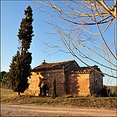
- The church of Sant Julià de Coaner , consecrated in 1024, is one of the jewels of the Catalan Romanesque period .
- A single-nave Lady Chapel ( Santuari de la Mare de Déu de Coaner ) from 1654 with a two-part bell gable ( espadanya ) stands not far from the church. It contained a late Romanesque polychrome statue of the Virgin, which is currently being kept elsewhere; The late Baroque altarpiece from 1716, which fits exactly into the apse of the chapel , is of interest .
- Salo
- There are only sparse remains of the former castle.
- Castelltallat
- There is a megalithic dolmen in the area of the village . During excavations in 1920, bones of seven people, as well as ceramic fragments and smaller pieces of jewelry made of stone and metal were discovered.
- In 1999 a rampart from the Iberian period (6th century BC) was uncovered in the area of the castle ruins .
- The Romanesque church ( Església Sant Miquel ), enthroned on a mountain peak at a height of 900 meters , received two chapels in the 16th and 17th centuries; the furnishings include several baroque altars.
- A modern observatory is in the immediate vicinity .
literature
- Vicenç Buron: Esglésies Romàniques Catalanes. Artestudi Edicions, Barcelona 1977, pp. 84f, ISBN 84-85180-06-2 .
Web links
- Municipality of Sant Mateu de Bages - Photos
- Municipality of Sant Mateu de Bages, history and monuments - photos + info (Catalan)
Individual evidence
- ↑ Cifras oficiales de población resultantes de la revisión del Padrón municipal a 1 de enero . Population statistics from the Instituto Nacional de Estadística (population update).


