Castellfollit del Boix
| Castellfollit del Boix municipality | ||
|---|---|---|
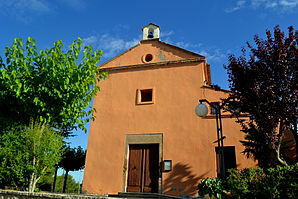
 Castellfollit del Boix - Church of Santa Maria
|
||
| coat of arms | Map of Spain | |

|
|
|
| Basic data | ||
| Autonomous Community : |
|
|
| Province : | Barcelona | |
| Comarca : | Bages | |
| Coordinates | 41 ° 40 ′ N , 1 ° 41 ′ E | |
| Height : | 700 msnm | |
| Area : | 59.29 km² | |
| Residents : | 436 (Jan. 1, 2019) | |
| Population density : | 7.35 inhabitants / km² | |
| Postal code : | 08255 | |
| Municipality number ( INE ): | 08059 | |
| administration | ||
| Website : | www.castellfollitdelboix.cat | |
Castellfollit del Boix is a place and a municipality ( municipi ) with 436 inhabitants (as of January 1, 2019) in the comarca of Bages in the province of Barcelona in the autonomous region of Catalonia . The municipality also includes the villages and hamlets Canyelles, El Castell, Grevalosa, Maians and Permanyer .
location
The place Castellfollit del Boix is at an altitude of about 700 meters above sea level. d. M. in the south of the Comarca Bages in the cultural and wine landscape Pla de Bages . The cities of Manresa and Barcelona are located about 17 kilometers northeast and 74 kilometers (driving distance) southeast.
Population development
| year | 1960 | 1970 | 1981 | 1990 | 2000 | 2010 |
| Residents | 581 | 421 | 318 | 315 | 383 | 413 |
In the middle of the 19th century the community had around 900 inhabitants; the phylloxera crisis in viticulture caused a decline at the end of the 19th century. The increasing mechanization of agriculture led to another slump in population in the second half of the 20th century. The relative proximity to the city of Manresa has resulted in an increase again in recent decades.
economy
In the past, the inhabitants lived mainly as a self-sufficiency from agriculture , which also included growing wine and keeping livestock (especially sheep and goats ). In the Middle Ages , Castellfollit also functioned as a craft and mercantile center for the villages and individual farms ( masies ) in the area. In the late 18th and early 19th centuries, viticulture played a major role in the region, but the phylloxera crisis put an end to this. A wind farm was installed on the ridge of the Serra de Rubió .
history
Prehistoric, Iberian , ancient and Visigoth burial grounds indicate a long period of settlement in the region. In the 9th and 10th centuries the almost deserted area - after the advance of Islam - was recaptured ( reconquista ) by the counts of Barcelona , repopulated ( repoblación ) and secured with castles ( castells ) and churches ( esglésies or ermitas ).
Attractions
- Several burial sites from prehistoric, Iberian and late antique times have been discovered in the area of the municipality (→ web link).
- There are several Romanesque chapels distributed over the municipality , but they are all in a ruinous state.
- Several guard huts ( barracas ) made of dry masonry are a reminder of the once important role of viticulture.
- Castellfollite
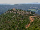
- From the early medieval castle ( castell ) only a few remains are visible.
- From standing on a mountainous hillside Romanesque church of Sant Pere is chancel received with three apses; these show pilaster strips with round arch friezes as the top. The interior of the church building, oriented in north-south direction, is a radical renovation of the 17th / 18th centuries. Century. In the former north apse is a sarcophagus with crosses and diamond ornaments, which was later used as a fountain or cattle trough. On a clear day, the Montserrat mountain range, located about 20 kilometers southeast, can be seen.
- You don't really know what to do with the slightly conical round tower Torre dels Moros (→ Weblink) - some see it as a watchtower from the Moorish era (see atalaya ); however, the masonry is made of comparatively precisely hewn stones that are arranged in layers. The window and front door are completely straight bricked, so that others want to see the stump of a windmill in it, which seems more likely overall.
- The current parish church of Santa María is a building from the beginning of the 20th century.
- Grevalosa
- The ruinous Romanesque chapel of Santa Cecília is located on a hill surrounded by large rocks, which may have previously served as a fortress.
- Maians
- The baroque church of Sant Andreu dates from the 18th century.
Web links
- Municipality of Castellfollit del Boix, history and monuments - photos + info (catalan)
- Municipality of Castellfollit del Boix, recent sights - Photos + information (Catalan)
- Municipality of Castellfollit del Boix, Torre dels Moros - Photos + information (Catalan)
Individual evidence
- ↑ Cifras oficiales de población resultantes de la revisión del Padrón municipal a 1 de enero . Population statistics from the Instituto Nacional de Estadística (population update).


