
El Pont de Vilomara i Rocafort
| Municipality of El Pont de Vilomara i Rocafort | |||
|---|---|---|---|
 El Pont de Vilomara
|
|||
| coat of arms | Map of Spain | ||

|
|
||
| Basic data | |||
| Autonomous Community : |
|
||
| Province : | Barcelona | ||
| Comarca : | Bages | ||
| Coordinates | 41 ° 42 ′ N , 1 ° 52 ′ E | ||
| Height : | 202 msnm | ||
| Area : | 27.65 km² | ||
| Residents : | 3,830 (Jan 1, 2019) | ||
| Population density : | 138.52 inhabitants / km² | ||
| Postal code : | 08254 | ||
| Municipality number ( INE ): | 08182 | ||
| administration | |||
| Website : | www.elpont.cat | ||

El Pont de Vilomara i Rocafort (sometimes also referred to as Rocafort i Vilumara ) is a municipality ( municipi ) with 3830 inhabitants (as of January 1, 2019) in the comarca of Bages in the province of Barcelona in the autonomous region of Catalonia . The community consists of the two places El Pont de Vilomara and Rocafort as well as several individual farms.
location
The by far larger district of El Pont de Vilomara is located at an altitude of about 200 meters above sea level. d. M. on the east bank of the Riu Llobregat ; the district Rocafort, which has only about 50 inhabitants, is located about seven kilometers (driving distance) southeast on the northwestern edge of the Parque natural de Sant Llorenç del Munt i l'Obac at an altitude of about 300 meters above sea level. d. The neighboring town of Talamanca is well worth seeing and is located about 25 kilometers to the northeast. The cities of Barcelona and Manresa are about 68 kilometers southeast and about eight kilometers northwest, respectively.
Population development
| year | 1960 | 1970 | 1981 | 1990 | 2000 | 2010 |
| Residents | 1.933 | 2.017 | 2,109 | 2,226 | 2,668 | 2,751 |
In the middle of the 19th century the community had about 850 inhabitants; Since then, the population has continued to grow, which was not interrupted by the phylloxera crisis in viticulture and the mechanization of agriculture and is mainly due to the proximity to the city of Manresa.
economy
In the past, the inhabitants lived mainly as a self-sufficient living from agriculture , which also included growing wine and keeping cattle. In the early 19th century, the Pla de Bages region developed into an important wine-growing region , but as a result the communities suffered particularly from the phylloxera crisis . In the last few decades, smaller industrial companies have settled here.
history
There was probably a bridge over the Riu Llobregat already in ancient times, which on the one hand promoted the developing place, but on the other hand was also repeatedly exposed to attacks. In the 9th and 10th centuries, the area was recaptured ( reconquista ) and repopulated ( repoblación ) by the Counts of Barcelona . Documents tell of many dead and refugees during the plague epidemic of 1348.
Attractions
- El Pont de Vilomara
- The place bears its name because of a bridge over the Riu Llobregat that probably already existed in Roman times ; However, this was changed again and again and serves as a road bridge to this day. An elegant-looking six-arched bridge from the late Middle Ages is about 500 meters further south.
- The Romanesque hermit church ( Ermita de Santa Magdalena del Pla ) in the cemetery is mentioned for the first time in a document from 1077, but the unadorned building probably dates from the 12th century. The portal originally located on the south side was bricked up at some point and replaced by one on the west side.

- The eastern parts of the small church of Santa Maria de Matadars or Santa Maria del Marquet , about one kilometer south of the village, still belong to the pre-Romanesque period (9th or 10th century). The transition to the apse is formed by a horseshoe arch . The single nave nave of the church, however, is from the Romanesque period (11th / 12th centuries). The church is one of the architectural treasures of the region.
- Rocafort

- From the already mentioned in the years 902 and 1023 medieval castle ( castell ) are only ruins.
- The rural Gothic church of Santa Maria dates from the 13th / 14th centuries. Century and is - although it was built on the site of a Romanesque predecessor - oriented in north-south direction. The barrel vault of the single-nave church is slightly pointed at the top. In the 16./17. In the 19th century two chapels were added.
- Around 30 crosses have been carved into a natural rock ( Roca de les Creus ) in the past centuries.
- In the village there is a small, privately run museum with rural work and household equipment, etc.
- Surroundings
- Several small wine press houses ( tines ) have been preserved in the municipality, which used to stand on the edge of vineyards and enabled the grapes to be processed quickly (pressing and fermentation).

Tines d'en Bleda
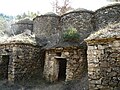
Tines d'en Bleda

Tines de Balmes Roges

Tines de l'Escudelleta
.jpg)


literature
- Vicenç Buron: Esglésies Romàniques Catalanes. Artestudi Edicions, Barcelona 1977, p. 88, ISBN 84-85180-06-2 .
Web links
- El Pont de Vilomara, sights - photos + info (catalan)
- Rocafort, sights - photos + info (catalan)
- Press vats in the vineyards, history and functionality - photos + information (Wikipedia, Catalan)
Individual evidence
- ↑ Cifras oficiales de población resultantes de la revisión del Padrón municipal a 1 de enero . Population statistics from the Instituto Nacional de Estadística (population update).
Aguilar de Segarra | Artés | Avinyó | Balsareny | Callus | Cardona | Castellbell i el Vilar | Castellfollit del Boix | Castellgalí | Castellnou de Bages | Fonollosa | Gaià | Manresa | Marganell | Monistrol de Montserrat | Mura | Navarcles | Navàs | El Pont de Vilomara i Rocafort | Rajadell | Sallent | Sant Feliu Sasserra | Sant Fruitós de Bages | Sant Joan de Vilatorrada | Sant Mateu de Bages | Sant Salvador de Guardiola | Sant Vicenç de Castellet | Santpedor | Súria | Talamanca